Humada geodata
Humada (Castille and León) is a seat of a third-order administrative division; located in Spain in Europe/Madrid (GMT+2) time zone. With population of 173 people, there are 5237 cities with bigger population in this country. Compared to other cities in Spain, 91% of cities are located further ↓South; 61% of cities are located further →East and 85.5% of cities have lower elevation than Humada. Note1


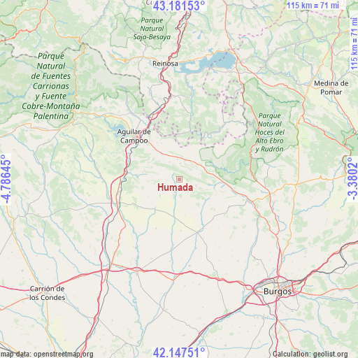
Humada GPS coordinates[2]
42° 40' 0.012" North, 4° 4' 59.988" West
| Map corner | latitude | longitude |
|---|---|---|
| Upper-left | 43.18153°, | -4.78645° |
| Center: | 42.66667°, | -4.08333° |
| Lower-right: | 42.14751°, | -3.3802° |
| Map W x H: | 115×115 km | = 71.5×71.5mi |
| max Lat: | 43.74134° ⇑9% North |
| Humada: | 42.66667° |
| min Lat: | ⇓91% South 27.64134° |
| min Long | Humada | max Long |
| -18.00367° | -4.08333° | 4.2899° |
| W 39%⇐ | ⇒61% E |
Elevation
Elevation of Humada is 958 m = 3143 ft, and this is 360 m = 1181 ft above average elevation for this country.
| Max E: |
1682 m = 5518 ft | 14.5% |
| Humada | 958 m 3143 ft | |
| Avg. | 598 m = 1962 ft | |
Min E: |
0 m = 0 ft | 85.5% |
See also: Spain elevation on elevation.city.
Geographical zone
Humada is located in North temperate zone (between Tropic of Cancer and the Arctic Circle). Distance of this Northern Tropic circle is 2138.2 km =1328.6 mi to South.| Distance of | km | miles | from Humada |
|---|---|---|---|
| North Pole | 5263 | 3270.3 | to North |
| Arctic Circle | 2657.1 | 1651 | to North |
| Tropic Cancer | 2138.2 | 1328.6 | to South |
| Equator | 4744.1 | 2947.8 | to South |


Nearby cities:
15 places around Humada: (largest is in red/bold)
• Aguilar de Campoo
20.2 km =12.6 mi,  314°
314°
• Alar del Rey
18.8 km =11.7 mi,  267°
267°
• Basconcillos del Tozo
8.6 km =5.3 mi,  62°
62°
• Berzosilla
13.2 km =8.2 mi,  16°
16°
• Herrera de Pisuerga
21.7 km =13.5 mi,  248°
248°
• Pomar de Valdivia
13.8 km =8.6 mi,  330°
330°
• Prádanos de Ojeda
21.6 km =13.4 mi, 274°
• Rebolledo de la Torre
12 km =7.5 mi,  282°
282°
• Rezmondo
21.1 km =13.1 mi,  217°
217°
• Sargentes de la Lora
20.6 km =12.8 mi, 56°
• Sordillos
22.8 km =14.2 mi,  184°
184°
• Sotresgudo
12.4 km =7.7 mi, 218°
• Villadiego
17.8 km =11.1 mi,  160°
160°
• Villamayor de Treviño
23.1 km =14.4 mi,  187°
187°
• Villegas
22.7 km =14.1 mi,  166°
166°
Sources, notices
• [Note1] Compared only with cities in Spain existing in our database
• [Src1] Map data: © OpenStreetMap contributors (CC-BY-SA)
• [Src2] Other city data from geonames.org with taken over terms of usage.
• [Src3] Geographical zone / Annual Mean Temperature by Robert A. Rohde @ Wikipedia
