Berzosilla geodata
Berzosilla (Castille and León) is a seat of a third-order administrative division; located in Spain in Europe/Madrid (GMT+2) time zone. With population of 62 people, there are 6325 cities with bigger population in this country. Compared to other cities in Spain, 92.5% of cities are located further ↓South; 60.3% of cities are located further →East and 70.6% of cities have lower elevation than Berzosilla. Note1
Administrative division(s):
- Level 1: Castille and León
- Level 2: Provincia de Palencia
- Level 3: Berzosilla


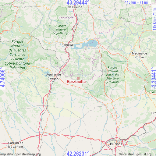
Berzosilla GPS coordinates[2]
42° 46' 49.908" North, 4° 2' 15.108" West
| Map corner | latitude | longitude |
|---|---|---|
| Upper-left | 43.29444°, | -4.74066° |
| Center: | 42.78053°, | -4.03753° |
| Lower-right: | 42.26231°, | -3.33441° |
| Map W x H: | 114.8×114.8 km | = 71.3×71.3mi |
| max Lat: | 43.74134° ⇑7.5% North |
| Berzosilla: | 42.78053° |
| min Lat: | ⇓92.5% South 27.64134° |
| min Long | Berzosilla | max Long |
| -18.00367° | -4.03753° | 4.2899° |
| W 39.7%⇐ | ⇒60.3% E |
Elevation
Elevation of Berzosilla is 818 m = 2684 ft, and this is 220 m = 722 ft above average elevation for this country.
| Max E: |
1682 m = 5518 ft | 29.4% |
| Berzosilla | 818 m 2684 ft | |
| Avg. | 598 m = 1962 ft | |
Min E: |
0 m = 0 ft | 70.6% |
See also: Spain elevation on elevation.city.
Geographical zone
Berzosilla is located in North temperate zone (between Tropic of Cancer and the Arctic Circle). Distance of this Northern Tropic circle is 2150.8 km =1336.4 mi to South.| Distance of | km | miles | from Berzosilla |
|---|---|---|---|
| North Pole | 5250.3 | 3262.4 | to North |
| Arctic Circle | 2644.4 | 1643.2 | to North |
| Tropic Cancer | 2150.8 | 1336.4 | to South |
| Equator | 4756.7 | 2955.7 | to South |


Nearby cities:
15 places around Berzosilla: (largest is in red/bold)
• Aguilar de Campoo
18.1 km =11.2 mi,  274°
274°
• Arija
24.9 km =15.5 mi,  17°
17°
• Barruelo de Santullán
24.6 km =15.3 mi,  304°
304°
• Basconcillos del Tozo
9.5 km =5.9 mi,  155°
155°
• Humada
13.2 km =8.2 mi,  196°
196°
• Mataporquera
14.6 km =9.1 mi,  315°
315°
• Pomar de Valdivia
10.6 km =6.6 mi, 266°
• Rebolledo de la Torre
18.5 km =11.5 mi,  236°
236°
• Reinosa
25.7 km =16 mi,  341°
341°
• San Martín de Elines
14.8 km =9.2 mi,  68°
68°
• Sargentes de la Lora
13.5 km =8.4 mi,  95°
95°
• Sedano
24.5 km =15.2 mi,  106°
106°
• Sotresgudo
25.1 km =15.6 mi,  207°
207°
• Tubilla del Agua
20.9 km =13 mi, 112°
• Villaescusa
22.8 km =14.2 mi,  332°
332°
Sources, notices
• [Note1] Compared only with cities in Spain existing in our database
• [Src1] Map data: © OpenStreetMap contributors (CC-BY-SA)
• [Src2] Other city data from geonames.org with taken over terms of usage.
• [Src3] Geographical zone / Annual Mean Temperature by Robert A. Rohde @ Wikipedia
