Aguilar de Campoo geodata
Aguilar de Campoo (Castille and León) is a seat of a third-order administrative division; located in Spain in Europe/Madrid (GMT+2) time zone. With population of 7,280 people, there are 1004 cities with bigger population in this country. Compared to other cities in Spain, 92.6% of cities are located further ↓South; 63.3% of cities are located further →East and 80.7% of cities have lower elevation than Aguilar de Campoo. Note1
Administrative division(s):
- Level 1: Castille and León
- Level 2: Provincia de Palencia
- Level 3: Aguilar de Campoo


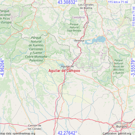
Aguilar de Campoo GPS coordinates[2]
42° 47' 40.272" North, 4° 15' 32.112" West
| Map corner | latitude | longitude |
|---|---|---|
| Upper-left | 43.30832°, | -4.96204° |
| Center: | 42.79452°, | -4.25892° |
| Lower-right: | 42.27642°, | -3.55579° |
| Map W x H: | 114.7×114.7 km | = 71.3×71.3mi |
| max Lat: | 43.74134° ⇑7.4% North |
| Aguilar de Campoo: | 42.79452° |
| min Lat: | ⇓92.6% South 27.64134° |
| min Long | Aguilar de Camp | max Long |
| -18.00367° | -4.25892° | 4.2899° |
| W 36.7%⇐ | ⇒63.3% E |
Elevation
Elevation of Aguilar de Campoo is 904 m = 2966 ft, and this is 306 m = 1004 ft above average elevation for this country.
| Max E: |
1682 m = 5518 ft | 19.3% |
| Aguilar de Campoo | 904 m 2966 ft | |
| Avg. | 598 m = 1962 ft | |
Min E: |
0 m = 0 ft | 80.7% |
See also: Spain elevation on elevation.city.
Geographical zone
Aguilar de Campoo is located in North temperate zone (between Tropic of Cancer and the Arctic Circle). Distance of this Northern Tropic circle is 2152.4 km =1337.4 mi to South.| Distance of | km | miles | from Aguilar de Campoo |
|---|---|---|---|
| North Pole | 5248.8 | 3261.5 | to North |
| Arctic Circle | 2642.9 | 1642.2 | to North |
| Tropic Cancer | 2152.4 | 1337.4 | to South |
| Equator | 4758.3 | 2956.7 | to South |


Nearby cities:
15 places around Aguilar de Campoo: (largest is in red/bold)
• Alar del Rey
15.5 km =9.6 mi,  196°
196°
• Barruelo de Santullán
12.6 km =7.8 mi,  349°
349°
• Berzosilla
18.1 km =11.2 mi,  94°
94°
• Brañosera
16.3 km =10.1 mi, 345°
• Mataporquera
11.9 km =7.4 mi,  41°
41°
• Mudá
14.2 km =8.8 mi,  309°
309°
• Olmos de Ojeda
15.7 km =9.8 mi,  239°
239°
• Payo de Ojeda
19.7 km =12.2 mi, 244°
• Pomar de Valdivia
7.8 km =4.8 mi,  106°
106°
• Prádanos de Ojeda
14.5 km =9 mi,  209°
209°
• Rebolledo de la Torre
12 km =7.5 mi,  167°
167°
• Salinas de Pisuerga
11.5 km =7.1 mi,  302°
302°
• San Cebrián de Mudá
15.1 km =9.4 mi,  316°
316°
• Santibáñez de Ecla
13.4 km =8.3 mi,  223°
223°
• Villaescusa
20.1 km =12.5 mi,  21°
21°
Sources, notices
• [Note1] Compared only with cities in Spain existing in our database
• [Src1] Map data: © OpenStreetMap contributors (CC-BY-SA)
• [Src2] Other city data from geonames.org with taken over terms of usage.
• [Src3] Geographical zone / Annual Mean Temperature by Robert A. Rohde @ Wikipedia
