Hueva geodata
Hueva (Castille-La Mancha) is a seat of a third-order administrative division; located in Spain in Europe/Madrid (GMT+2) time zone. With population of 146 people, there are 5457 cities with bigger population in this country. Compared to other cities in Spain, 62.7% of cities are located further ↑North; 55.1% of cities are located further ←West and 80% of cities have lower elevation than Hueva. Note1
Administrative division(s):
- Level 1: Castille-La Mancha
- Level 2: Provincia de Guadalajara
- Level 3: Hueva


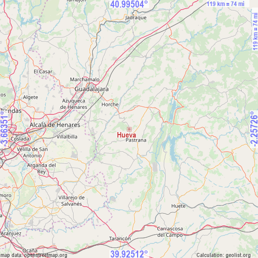
Hueva GPS coordinates[2]
40° 27' 43.956" North, 2° 57' 37.404" West
| Map corner | latitude | longitude |
|---|---|---|
| Upper-left | 40.99504°, | -3.66351° |
| Center: | 40.46221°, | -2.96039° |
| Lower-right: | 39.92512°, | -2.25726° |
| Map W x H: | 119×119 km | = 73.9×73.9mi |
| max Lat: | 43.74134° ⇑62.7% North |
| Hueva: | 40.46221° |
| min Lat: | ⇓37.3% South 27.64134° |
| min Long | Hueva | max Long |
| -18.00367° | -2.96039° | 4.2899° |
| W 55.1%⇐ | ⇒44.9% E |
Elevation
Elevation of Hueva is 897 m = 2943 ft, and this is 299 m = 981 ft above average elevation for this country.
| Max E: |
1682 m = 5518 ft | 20% |
| Hueva | 897 m 2943 ft | |
| Avg. | 598 m = 1962 ft | |
Min E: |
0 m = 0 ft | 80% |
See also: Spain elevation on elevation.city.
Geographical zone
Hueva is located in North temperate zone (between Tropic of Cancer and the Arctic Circle). Distance of this Northern Tropic circle is 1893.1 km =1176.3 mi to South.| Distance of | km | miles | from Hueva |
|---|---|---|---|
| North Pole | 5508.1 | 3422.6 | to North |
| Arctic Circle | 2902.2 | 1803.3 | to North |
| Tropic Cancer | 1893.1 | 1176.3 | to South |
| Equator | 4499 | 2795.5 | to South |


Nearby cities:
15 places around Hueva: (largest is in red/bold)
• Aranzueque
10.2 km =6.3 mi,  288°
288°
• Armuña de Tajuña
9.4 km =5.8 mi,  322°
322°
• Escariche
10.1 km =6.3 mi,  231°
231°
• Escopete
6.6 km =4.1 mi,  214°
214°
• Fuentelencina
9 km =5.6 mi,  46°
46°
• Fuentelviejo
7.4 km =4.6 mi,  344°
344°
• Hontoba
6.7 km =4.2 mi,  262°
262°
• Loranca de Tajuña
12.9 km =8 mi, 260°
• Moratilla de los Meleros
4.6 km =2.9 mi,  18°
18°
• Pastrana
5.8 km =3.6 mi,  146°
146°
• Renera
5.4 km =3.4 mi,  304°
304°
• Romanones
12.4 km =7.7 mi,  348°
348°
• Tendilla
9.1 km =5.7 mi,  1°
1°
• Valdeconcha
7.1 km =4.4 mi,  95°
95°
• Yebra
11.7 km =7.3 mi,  182°
182°
Sources, notices
• [Note1] Compared only with cities in Spain existing in our database
• [Src1] Map data: © OpenStreetMap contributors (CC-BY-SA)
• [Src2] Other city data from geonames.org with taken over terms of usage.
• [Src3] Geographical zone / Annual Mean Temperature by Robert A. Rohde @ Wikipedia
