Fuentelencina geodata
Fuentelencina (Castille-La Mancha) is a seat of a third-order administrative division; located in Spain in Europe/Madrid (GMT+2) time zone. With population of 237 people, there are 4822 cities with bigger population in this country. Compared to other cities in Spain, 61.4% of cities are located further ↑North; 56.3% of cities are located further ←West and 86.9% of cities have lower elevation than Fuentelencina. Note1
Administrative division(s):
- Level 1: Castille-La Mancha
- Level 2: Provincia de Guadalajara
- Level 3: Fuentelencina


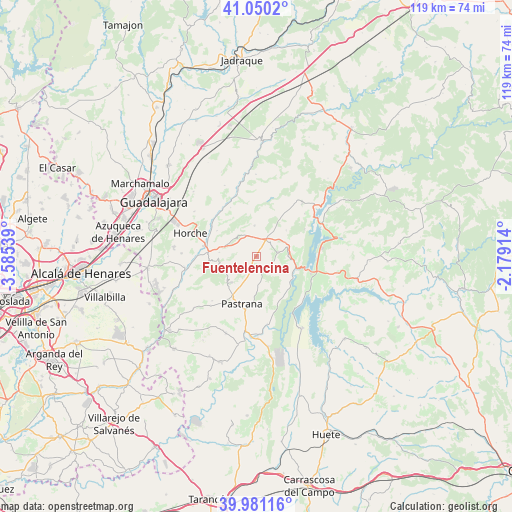
Fuentelencina GPS coordinates[2]
40° 31' 4.116" North, 2° 52' 56.136" West
| Map corner | latitude | longitude |
|---|---|---|
| Upper-left | 41.0502°, | -3.58539° |
| Center: | 40.51781°, | -2.88226° |
| Lower-right: | 39.98116°, | -2.17914° |
| Map W x H: | 118.9×118.9 km | = 73.9×73.9mi |
| max Lat: | 43.74134° ⇑61.4% North |
| Fuentelencina: | 40.51781° |
| min Lat: | ⇓38.6% South 27.64134° |
| min Long | Fuentelencina | max Long |
| -18.00367° | -2.88226° | 4.2899° |
| W 56.3%⇐ | ⇒43.7% E |
Elevation
Elevation of Fuentelencina is 978 m = 3209 ft, and this is 380 m = 1247 ft above average elevation for this country.
| Max E: |
1682 m = 5518 ft | 13.1% |
| Fuentelencina | 978 m 3209 ft | |
| Avg. | 598 m = 1962 ft | |
Min E: |
0 m = 0 ft | 86.9% |
See also: Spain elevation on elevation.city.
Geographical zone
Fuentelencina is located in North temperate zone (between Tropic of Cancer and the Arctic Circle). Distance of this Northern Tropic circle is 1899.2 km =1180.1 mi to South.| Distance of | km | miles | from Fuentelencina |
|---|---|---|---|
| North Pole | 5501.9 | 3418.7 | to North |
| Arctic Circle | 2896 | 1799.5 | to North |
| Tropic Cancer | 1899.2 | 1180.1 | to South |
| Equator | 4505.2 | 2799.4 | to South |


Nearby cities:
15 places around Fuentelencina: (largest is in red/bold)
• Alhóndiga
5 km =3.1 mi,  78°
78°
• Armuña de Tajuña
12.4 km =7.7 mi,  275°
275°
• Auñón
7.6 km =4.7 mi,  90°
90°
• Berninches
9.1 km =5.7 mi,  49°
49°
• Fuentelviejo
8.7 km =5.4 mi, 276°
• Hueva
9 km =5.6 mi,  226°
226°
• Irueste
10.5 km =6.5 mi,  356°
356°
• Moratilla de los Meleros
5.4 km =3.4 mi,  250°
250°
• Pastrana
11.5 km =7.1 mi,  197°
197°
• Peñalver
7.1 km =4.4 mi, 355°
• Renera
11.5 km =7.1 mi, 254°
• Romanones
10.9 km =6.8 mi,  303°
303°
• Tendilla
7 km =4.3 mi,  294°
294°
• Valdeconcha
6.8 km =4.2 mi,  176°
176°
• Yélamos de Abajo
12.7 km =7.9 mi,  9°
9°
Sources, notices
• [Note1] Compared only with cities in Spain existing in our database
• [Src1] Map data: © OpenStreetMap contributors (CC-BY-SA)
• [Src2] Other city data from geonames.org with taken over terms of usage.
• [Src3] Geographical zone / Annual Mean Temperature by Robert A. Rohde @ Wikipedia
