Escopete geodata
Escopete (Castille-La Mancha) is a seat of a third-order administrative division; located in Spain in Europe/Madrid (GMT+2) time zone. With population of 74 people, there are 6204 cities with bigger population in this country. Compared to other cities in Spain, 63.7% of cities are located further ↑North; 54.4% of cities are located further ←West and 79.3% of cities have lower elevation than Escopete. Note1
Administrative division(s):
- Level 1: Castille-La Mancha
- Level 2: Provincia de Guadalajara
- Level 3: Escopete


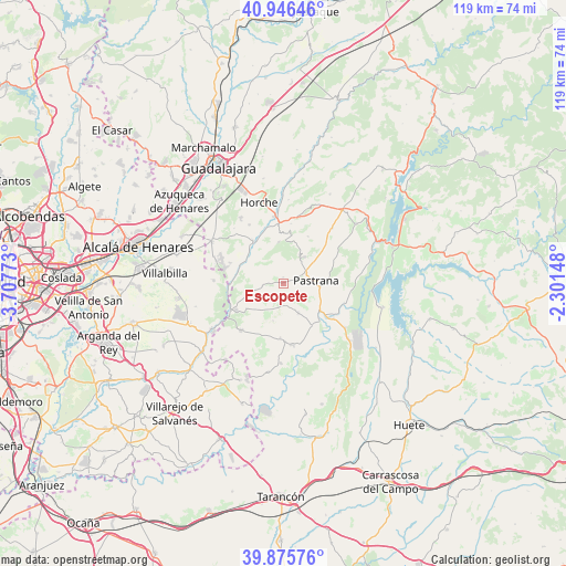
Escopete GPS coordinates[2]
40° 24' 47.664" North, 3° 0' 16.56" West
| Map corner | latitude | longitude |
|---|---|---|
| Upper-left | 40.94646°, | -3.70773° |
| Center: | 40.41324°, | -3.0046° |
| Lower-right: | 39.87576°, | -2.30148° |
| Map W x H: | 119.1×119 km | = 74×73.9mi |
| max Lat: | 43.74134° ⇑63.7% North |
| Escopete: | 40.41324° |
| min Lat: | ⇓36.3% South 27.64134° |
| min Long | Escopete | max Long |
| -18.00367° | -3.0046° | 4.2899° |
| W 54.4%⇐ | ⇒45.6% E |
Elevation
Elevation of Escopete is 891 m = 2923 ft, and this is 293 m = 961 ft above average elevation for this country.
| Max E: |
1682 m = 5518 ft | 20.7% |
| Escopete | 891 m 2923 ft | |
| Avg. | 598 m = 1962 ft | |
Min E: |
0 m = 0 ft | 79.3% |
See also: Spain elevation on elevation.city.
Geographical zone
Escopete is located in North temperate zone (between Tropic of Cancer and the Arctic Circle). Distance of this Northern Tropic circle is 1887.6 km =1172.9 mi to South.| Distance of | km | miles | from Escopete |
|---|---|---|---|
| North Pole | 5513.5 | 3425.9 | to North |
| Arctic Circle | 2907.6 | 1806.7 | to North |
| Tropic Cancer | 1887.6 | 1172.9 | to South |
| Equator | 4493.5 | 2792.1 | to South |


Nearby cities:
15 places around Escopete: (largest is in red/bold)
• Albares
11.8 km =7.3 mi,  181°
181°
• Almoguera
13 km =8.1 mi,  171°
171°
• Aranzueque
10.5 km =6.5 mi,  325°
325°
• Escariche
4.2 km =2.6 mi,  258°
258°
• Fuentelviejo
12.7 km =7.9 mi,  7°
7°
• Fuentenovilla
9.2 km =5.7 mi,  232°
232°
• Hontoba
5.4 km =3.4 mi, 327°
• Hueva
6.6 km =4.1 mi,  34°
34°
• Loranca de Tajuña
9.6 km =6 mi,  290°
290°
• Moratilla de los Meleros
11.2 km =7 mi, 27°
• Pastrana
7 km =4.3 mi,  84°
84°
• Pozo de Almoguera
8.3 km =5.2 mi,  192°
192°
• Renera
8.5 km =5.3 mi,  354°
354°
• Valdeconcha
11.8 km =7.3 mi,  66°
66°
• Yebra
7 km =4.3 mi,  152°
152°
Sources, notices
• [Note1] Compared only with cities in Spain existing in our database
• [Src1] Map data: © OpenStreetMap contributors (CC-BY-SA)
• [Src2] Other city data from geonames.org with taken over terms of usage.
• [Src3] Geographical zone / Annual Mean Temperature by Robert A. Rohde @ Wikipedia
