Hormilla geodata
Hormilla (La Rioja) is a seat of a third-order administrative division; located in Spain in Europe/Madrid (GMT+2) time zone. With population of 435 people, there are 4041 cities with bigger population in this country. Compared to other cities in Spain, 85.9% of cities are located further ↓South; 57.7% of cities are located further ←West and 60.4% of cities have higher elevation than Hormilla. Note1


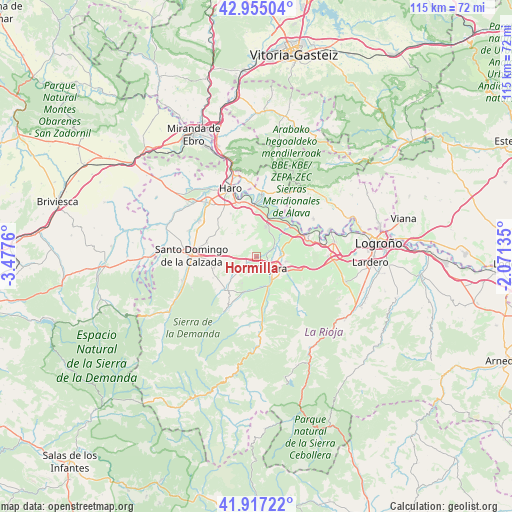
Hormilla GPS coordinates[2]
42° 26' 17.808" North, 2° 46' 28.092" West
| Map corner | latitude | longitude |
|---|---|---|
| Upper-left | 42.95504°, | -3.4776° |
| Center: | 42.43828°, | -2.77447° |
| Lower-right: | 41.91722°, | -2.07135° |
| Map W x H: | 115.4×115.4 km | = 71.7×71.7mi |
| max Lat: | 43.74134° ⇑14.1% North |
| Hormilla: | 42.43828° |
| min Lat: | ⇓85.9% South 27.64134° |
| min Long | Hormilla | max Long |
| -18.00367° | -2.77447° | 4.2899° |
| W 57.7%⇐ | ⇒42.3% E |
Elevation
Elevation of Hormilla is 521 m = 1709 ft, and this is 77 m = 253 ft below average elevation for this country.
| Max E: |
1682 m = 5518 ft | 60.4% |
| Avg. | 598 m = 1962 ft | |
| Hormilla | 521 m = 1709 ft | |
Min E: |
0 m = 0 ft | 39.6% |
See also: Spain elevation on elevation.city.
Geographical zone
Hormilla is located in North temperate zone (between Tropic of Cancer and the Arctic Circle). Distance of this Northern Tropic circle is 2112.8 km =1312.8 mi to South.| Distance of | km | miles | from Hormilla |
|---|---|---|---|
| North Pole | 5288.4 | 3286.1 | to North |
| Arctic Circle | 2682.5 | 1666.8 | to North |
| Tropic Cancer | 2112.8 | 1312.8 | to South |
| Equator | 4718.7 | 2932.1 | to South |


Nearby cities:
15 places around Hormilla: (largest is in red/bold)
• Alesanco
4.4 km =2.7 mi,  232°
232°
• Alesón
7.9 km =4.9 mi,  117°
117°
• Arenzana de Abajo
7.4 km =4.6 mi,  142°
142°
• Azofra
2.7 km =1.7 mi, 233°
• Canillas de Río Tuerto
7 km =4.3 mi, 231°
• Cañas
7.8 km =4.8 mi, 229°
• Cordovín
6.7 km =4.2 mi,  209°
209°
• Cárdenas
7.1 km =4.4 mi,  175°
175°
• Hormilleja
4.1 km =2.5 mi,  60°
60°
• Huércanos
6.5 km =4 mi,  100°
100°
• Nájera
4.4 km =2.7 mi, 120°
• San Asensio
6.8 km =4.2 mi,  16°
16°
• Torrecilla sobre Alesanco
5.9 km =3.7 mi,  235°
235°
• Tricio
6.1 km =3.8 mi,  131°
131°
• Uruñuela
5.5 km =3.4 mi,  84°
84°
Sources, notices
• [Note1] Compared only with cities in Spain existing in our database
• [Src1] Map data: © OpenStreetMap contributors (CC-BY-SA)
• [Src2] Other city data from geonames.org with taken over terms of usage.
• [Src3] Geographical zone / Annual Mean Temperature by Robert A. Rohde @ Wikipedia
