Hombrados geodata
Hombrados (Castille-La Mancha) is a seat of a third-order administrative division; located in Spain in Europe/Madrid (GMT+2) time zone. With population of 47 people, there are 6495 cities with bigger population in this country. Compared to other cities in Spain, 56.2% of cities are located further ↑North; 70.8% of cities are located further ←West and 97.5% of cities have lower elevation than Hombrados. Note1
Administrative division(s):
- Level 1: Castille-La Mancha
- Level 2: Provincia de Guadalajara
- Level 3: Hombrados


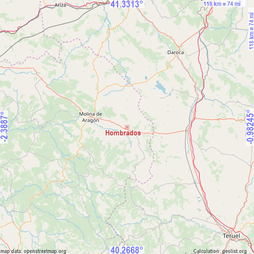
Hombrados GPS coordinates[2]
40° 48' 4.248" North, 1° 41' 8.088" West
| Map corner | latitude | longitude |
|---|---|---|
| Upper-left | 41.3313°, | -2.3887° |
| Center: | 40.80118°, | -1.68558° |
| Lower-right: | 40.2668°, | -0.98245° |
| Map W x H: | 118.4×118.4 km | = 73.6×73.6mi |
| max Lat: | 43.74134° ⇑56.2% North |
| Hombrados: | 40.80118° |
| min Lat: | ⇓43.8% South 27.64134° |
| min Long | Hombrados | max Long |
| -18.00367° | -1.68558° | 4.2899° |
| W 70.8%⇐ | ⇒29.2% E |
Elevation
Elevation of Hombrados is 1226 m = 4022 ft, and this is 628 m = 2060 ft above average elevation for this country.
| Max E: |
1682 m = 5518 ft | 2.5% |
| Hombrados | 1226 m 4022 ft | |
| Avg. | 598 m = 1962 ft | |
Min E: |
0 m = 0 ft | 97.5% |
See also: Spain elevation on elevation.city.
Geographical zone
Hombrados is located in North temperate zone (between Tropic of Cancer and the Arctic Circle). Distance of this Northern Tropic circle is 1930.7 km =1199.7 mi to South.| Distance of | km | miles | from Hombrados |
|---|---|---|---|
| North Pole | 5470.4 | 3399.1 | to North |
| Arctic Circle | 2864.5 | 1779.9 | to North |
| Tropic Cancer | 1930.7 | 1199.7 | to South |
| Equator | 4536.7 | 2819 | to South |


Nearby cities:
15 places around Hombrados: (largest is in red/bold)
• Adobes
13.9 km =8.6 mi,  177°
177°
• Anquela del Pedregal
7.7 km =4.8 mi,  213°
213°
• Campillo de Dueñas
9.2 km =5.7 mi,  0°
0°
• Castellar de la Muela
6.5 km =4 mi,  287°
287°
• Castilnuevo
14.6 km =9.1 mi,  275°
275°
• Morenilla
2.4 km =1.5 mi,  228°
228°
• Odón
13.5 km =8.4 mi,  47°
47°
• Piqueras
15.6 km =9.7 mi,  191°
191°
• Pozuel del Campo
15.5 km =9.6 mi,  102°
102°
• Prados Redondos
9.2 km =5.7 mi,  258°
258°
• Setiles
9.4 km =5.8 mi,  142°
142°
• Tordellego
8.9 km =5.5 mi,  171°
171°
• Tordesilos
16.4 km =10.2 mi,  151°
151°
• Torrecuadrada de Molina
11.7 km =7.3 mi,  240°
240°
• Torremochuela
13.8 km =8.6 mi,  253°
253°
Sources, notices
• [Note1] Compared only with cities in Spain existing in our database
• [Src1] Map data: © OpenStreetMap contributors (CC-BY-SA)
• [Src2] Other city data from geonames.org with taken over terms of usage.
• [Src3] Geographical zone / Annual Mean Temperature by Robert A. Rohde @ Wikipedia
