Odón geodata
Odón (Aragon) is a seat of a third-order administrative division; located in Spain in Europe/Madrid (GMT+2) time zone. With population of 257 people, there are 4702 cities with bigger population in this country. Compared to other cities in Spain, 54.2% of cities are located further ↑North; 72.2% of cities are located further ←West and 93% of cities have lower elevation than Odón. Note1


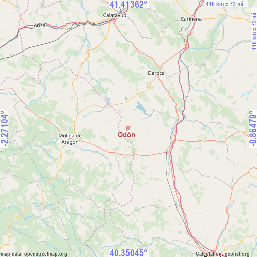
Odón GPS coordinates[2]
40° 53' 3.012" North, 1° 34' 4.512" West
| Map corner | latitude | longitude |
|---|---|---|
| Upper-left | 41.41362°, | -2.27104° |
| Center: | 40.88417°, | -1.56792° |
| Lower-right: | 40.35045°, | -0.86479° |
| Map W x H: | 118.2×118.2 km | = 73.4×73.4mi |
| max Lat: | 43.74134° ⇑54.2% North |
| Odón: | 40.88417° |
| min Lat: | ⇓45.8% South 27.64134° |
| min Long | Odón | max Long |
| -18.00367° | -1.56792° | 4.2899° |
| W 72.2%⇐ | ⇒27.8% E |
Elevation
Elevation of Odón is 1091 m = 3579 ft, and this is 493 m = 1617 ft above average elevation for this country.
| Max E: |
1682 m = 5518 ft | 7% |
| Odón | 1091 m 3579 ft | |
| Avg. | 598 m = 1962 ft | |
Min E: |
0 m = 0 ft | 93% |
See also: Spain elevation on elevation.city.
Geographical zone
Odón is located in North temperate zone (between Tropic of Cancer and the Arctic Circle). Distance of this Northern Tropic circle is 1940 km =1205.5 mi to South.| Distance of | km | miles | from Odón |
|---|---|---|---|
| North Pole | 5461.2 | 3393.4 | to North |
| Arctic Circle | 2855.3 | 1774.2 | to North |
| Tropic Cancer | 1940 | 1205.5 | to South |
| Equator | 4545.9 | 2824.7 | to South |


Nearby cities:
15 places around Odón: (largest is in red/bold)
• Bello
7.2 km =4.5 mi,  53°
53°
• Blancas
10.6 km =6.6 mi,  137°
137°
• Campillo de Dueñas
9.8 km =6.1 mi,  269°
269°
• Castejón de Tornos
17.2 km =10.7 mi,  43°
43°
• Castellar de la Muela
17.7 km =11 mi,  245°
245°
• Embid
15.6 km =9.7 mi,  309°
309°
• Gallocanta
13.4 km =8.3 mi,  22°
22°
• Hombrados
13.5 km =8.4 mi,  227°
227°
• Morenilla
15.9 km =9.9 mi, 227°
• Ojos Negros
17.3 km =10.7 mi,  160°
160°
• Pozuel del Campo
13.6 km =8.5 mi, 157°
• Santed
17.1 km =10.6 mi, 16°
• Setiles
17.2 km =10.7 mi,  193°
193°
• Tornos
14.2 km =8.8 mi, 52°
• Torralba de los Sisones
9.2 km =5.7 mi,  85°
85°
Sources, notices
• [Note1] Compared only with cities in Spain existing in our database
• [Src1] Map data: © OpenStreetMap contributors (CC-BY-SA)
• [Src2] Other city data from geonames.org with taken over terms of usage.
• [Src3] Geographical zone / Annual Mean Temperature by Robert A. Rohde @ Wikipedia
