Haza geodata
Haza (Castille and León) is a seat of a third-order administrative division; located in Spain in Europe/Madrid (GMT+2) time zone. With population of 36 people, there are 6610 cities with bigger population in this country. Compared to other cities in Spain, 63.8% of cities are located further ↓South; 57% of cities are located further →East and 80.9% of cities have lower elevation than Haza. Note1


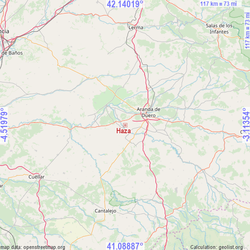
Haza GPS coordinates[2]
41° 37' 0.012" North, 3° 49' 0.012" West
| Map corner | latitude | longitude |
|---|---|---|
| Upper-left | 42.14019°, | -4.51979° |
| Center: | 41.61667°, | -3.81667° |
| Lower-right: | 41.08887°, | -3.11354° |
| Map W x H: | 116.9×116.9 km | = 72.6×72.6mi |
| max Lat: | 43.74134° ⇑36.2% North |
| Haza: | 41.61667° |
| min Lat: | ⇓63.8% South 27.64134° |
| min Long | Haza | max Long |
| -18.00367° | -3.81667° | 4.2899° |
| W 43%⇐ | ⇒57% E |
Elevation
Elevation of Haza is 906 m = 2972 ft, and this is 308 m = 1010 ft above average elevation for this country.
| Max E: |
1682 m = 5518 ft | 19.1% |
| Haza | 906 m 2972 ft | |
| Avg. | 598 m = 1962 ft | |
Min E: |
0 m = 0 ft | 80.9% |
See also: Spain elevation on elevation.city.
Geographical zone
Haza is located in North temperate zone (between Tropic of Cancer and the Arctic Circle). Distance of this Northern Tropic circle is 2021.4 km =1256 mi to South.| Distance of | km | miles | from Haza |
|---|---|---|---|
| North Pole | 5379.7 | 3342.8 | to North |
| Arctic Circle | 2773.8 | 1723.6 | to North |
| Tropic Cancer | 2021.4 | 1256 | to South |
| Equator | 4627.3 | 2875.3 | to South |


Nearby cities:
15 places around Haza: (largest is in red/bold)
• Adrada de Haza
2.5 km =1.6 mi,  192°
192°
• Berlangas de Roa
9.3 km =5.8 mi,  329°
329°
• Campillo de Aranda
7.2 km =4.5 mi,  95°
95°
• Castrillo de la Vega
4.9 km =3 mi,  37°
37°
• Fuentecén
4.5 km =2.8 mi,  286°
286°
• Fuentelisendo
7.1 km =4.4 mi,  275°
275°
• Fuentemolinos
3.1 km =1.9 mi,  244°
244°
• Fuentespina
11.1 km =6.9 mi,  81°
81°
• Hontangas
4.2 km =2.6 mi,  155°
155°
• Hoyales de Roa
6 km =3.7 mi,  321°
321°
• Milagros
10.8 km =6.7 mi,  115°
115°
• Moradillo de Roa
7.5 km =4.7 mi, 163°
• Torregalindo
6.5 km =4 mi, 124°
• Valdezate
9.6 km =6 mi,  260°
260°
• Villalba de Duero
9.5 km =5.9 mi, 39°
Sources, notices
• [Note1] Compared only with cities in Spain existing in our database
• [Src1] Map data: © OpenStreetMap contributors (CC-BY-SA)
• [Src2] Other city data from geonames.org with taken over terms of usage.
• [Src3] Geographical zone / Annual Mean Temperature by Robert A. Rohde @ Wikipedia
