Fuenlabrada geodata
Fuenlabrada (Madrid) is a seat of a third-order administrative division; located in Spain in Europe/Madrid (GMT+2) time zone. With population of 197,836 people, there are 37 cities with bigger population in this country. Compared to other cities in Spain, 66% of cities are located further ↑North; 56.7% of cities are located further →East and 51.2% of cities have lower elevation than Fuenlabrada. Note1


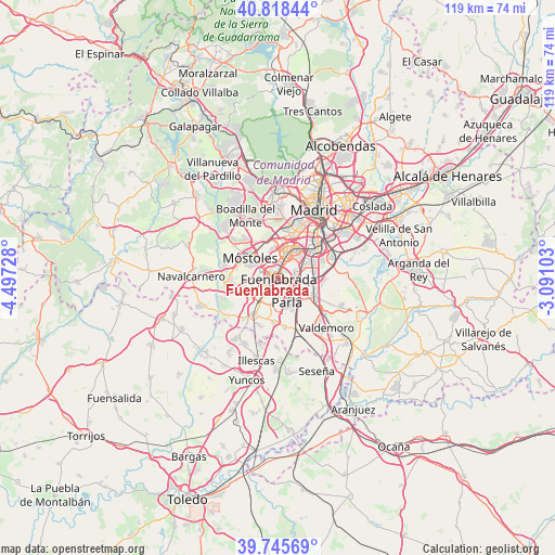
Fuenlabrada GPS coordinates[2]
40° 17' 3.084" North, 3° 47' 38.94" West
| Map corner | latitude | longitude |
|---|---|---|
| Upper-left | 40.81844°, | -4.49728° |
| Center: | 40.28419°, | -3.79415° |
| Lower-right: | 39.74569°, | -3.09103° |
| Map W x H: | 119.3×119.3 km | = 74.1×74.1mi |
| max Lat: | 43.74134° ⇑66% North |
| Fuenlabrada: | 40.28419° |
| min Lat: | ⇓34% South 27.64134° |
| min Long | Fuenlabrada | max Long |
| -18.00367° | -3.79415° | 4.2899° |
| W 43.3%⇐ | ⇒56.7% E |
Elevation
Elevation of Fuenlabrada is 671 m = 2201 ft, and this is 73 m = 240 ft above average elevation for this country.
| Max E: |
1682 m = 5518 ft | 48.8% |
| Fuenlabrada | 671 m 2201 ft | |
| Avg. | 598 m = 1962 ft | |
Min E: |
0 m = 0 ft | 51.2% |
See also: Fuenlabrada elevation on elevation.city.
Geographical zone
Fuenlabrada is located in North temperate zone (between Tropic of Cancer and the Arctic Circle). Distance of this Northern Tropic circle is 1873.3 km =1164 mi to South.| Distance of | km | miles | from Fuenlabrada |
|---|---|---|---|
| North Pole | 5527.9 | 3434.9 | to North |
| Arctic Circle | 2922 | 1815.6 | to North |
| Tropic Cancer | 1873.3 | 1164 | to South |
| Equator | 4479.2 | 2783.2 | to South |


Nearby cities:
15 places around Fuenlabrada: (largest is in red/bold)
• Alcorcón
7.3 km =4.5 mi,  339°
339°
• Arroyomolinos
10.8 km =6.7 mi,  261°
261°
• Cubas
11.1 km =6.9 mi,  198°
198°
• Getafe
5.7 km =3.5 mi,  65°
65°
• Griñón
9.5 km =5.9 mi,  212°
212°
• Humanes de Madrid
4.9 km =3 mi,  219°
219°
• Leganés
5.4 km =3.4 mi,  28°
28°
• Moraleja de Enmedio
6.1 km =3.8 mi,  245°
245°
• Móstoles
7.4 km =4.6 mi,  305°
305°
• Parla
5.8 km =3.6 mi,  157°
157°
• Pinto
9.3 km =5.8 mi,  120°
120°
• Serranillos del Valle
11.8 km =7.3 mi, 219°
• Torrejón de Velasco
10.9 km =6.8 mi,  172°
172°
• Torrejón de la Calzada
9.5 km =5.9 mi,  181°
181°
• Villaverde
10.8 km =6.7 mi,  47°
47°
Sources, notices
• [Note1] Compared only with cities in Spain existing in our database
• [Src1] Map data: © OpenStreetMap contributors (CC-BY-SA)
• [Src2] Other city data from geonames.org with taken over terms of usage.
• [Src3] Geographical zone / Annual Mean Temperature by Robert A. Rohde @ Wikipedia
