Gavà geodata
Gavà (Catalonia) is a seat of a third-order administrative division; located in Spain in Europe/Madrid (GMT+2) time zone. With population of 45,994 people, there are 191 cities with bigger population in this country. Compared to other cities in Spain, 55.4% of cities are located further ↓South; 93.5% of cities are located further ←West and 95.6% of cities have higher elevation than Gavà. Note1


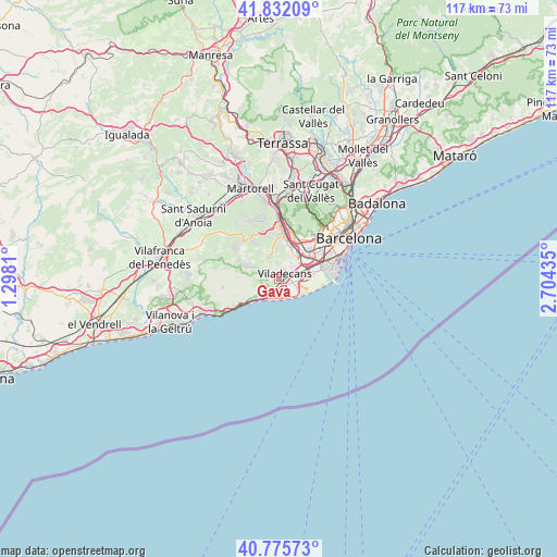
Gavà GPS coordinates[2]
41° 18' 21.78" North, 2° 0' 4.428" East
| Map corner | latitude | longitude |
|---|---|---|
| Upper-left | 41.83209°, | 1.2981° |
| Center: | 41.30605°, | 2.00123° |
| Lower-right: | 40.77573°, | 2.70435° |
| Map W x H: | 117.5×117.5 km | = 73×73mi |
| max Lat: | 43.74134° ⇑44.6% North |
| Gavà: | 41.30605° |
| min Lat: | ⇓55.4% South 27.64134° |
| min Long | Gavà | max Long |
| -18.00367° | 2.00123° | 4.2899° |
| W 93.5%⇐ | ⇒6.5% E |
Elevation
Elevation of Gavà is 22 m = 72 ft, and this is 576 m = 1890 ft below average elevation for this country.
| Max E: |
1682 m = 5518 ft | 95.6% |
| Avg. | 598 m = 1962 ft | |
| Gavà | 22 m = 72 ft | |
Min E: |
0 m = 0 ft | 4.4% |
See also: Gavà elevation on elevation.city.
Geographical zone
Gavà is located in North temperate zone (between Tropic of Cancer and the Arctic Circle). Distance of this Northern Tropic circle is 1986.9 km =1234.6 mi to South.| Distance of | km | miles | from Gavà |
|---|---|---|---|
| North Pole | 5414.3 | 3364.3 | to North |
| Arctic Circle | 2808.4 | 1745.1 | to North |
| Tropic Cancer | 1986.9 | 1234.6 | to South |
| Equator | 4592.8 | 2853.8 | to South |


Nearby cities:
15 places around Gavà: (largest is in red/bold)
• Begues
6.4 km =4 mi,  298°
298°
• Castelldefels
4.1 km =2.5 mi,  219°
219°
• Cervelló
10.6 km =6.6 mi,  340°
340°
• Cornellà de Llobregat
8.4 km =5.2 mi,  54°
54°
• El Prat de Llobregat
8.2 km =5.1 mi,  72°
72°
• Esplugues de Llobregat
10.7 km =6.6 mi,  42°
42°
• L'Hospitalet de Llobregat
10.2 km =6.3 mi, 54°
• Sant Boi de Llobregat
5.1 km =3.2 mi, 35°
• Sant Feliu de Llobregat
9.5 km =5.9 mi,  25°
25°
• Sant Joan Despí
8.3 km =5.2 mi, 34°
• Sant Just Desvern
10.3 km =6.4 mi, 32°
• Sant Vicenç dels Horts
9.7 km =6 mi,  2°
2°
• Santa Coloma de Cervelló
6.9 km =4.3 mi,  9°
9°
• Torrelles de Llobregat
5.1 km =3.2 mi, 342°
• Viladecans
1.4 km =0.9 mi, 50°
Sources, notices
• [Note1] Compared only with cities in Spain existing in our database
• [Src1] Map data: © OpenStreetMap contributors (CC-BY-SA)
• [Src2] Other city data from geonames.org with taken over terms of usage.
• [Src3] Geographical zone / Annual Mean Temperature by Robert A. Rohde @ Wikipedia
