Castelldefels geodata
Castelldefels (Catalonia) is a seat of a third-order administrative division; located in Spain in Europe/Madrid (GMT+2) time zone. With population of 62,080 people, there are 152 cities with bigger population in this country. Compared to other cities in Spain, 54.9% of cities are located further ↓South; 93.3% of cities are located further ←West and 97.3% of cities have higher elevation than Castelldefels. Note1
Administrative division(s):
- Level 1: Catalonia
- Level 2: Província de Barcelona
- Level 3: Castelldefels


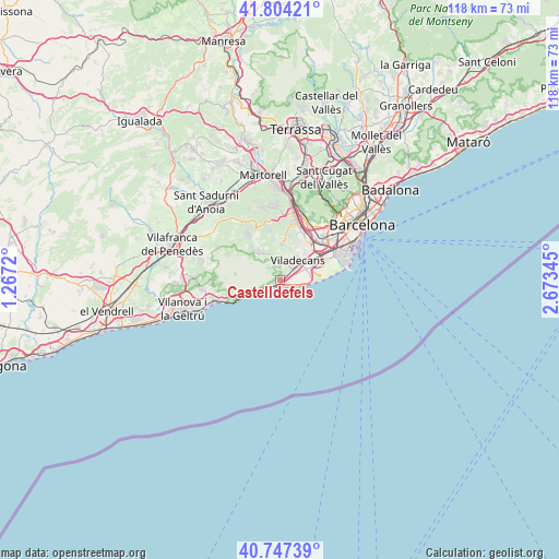
Castelldefels GPS coordinates[2]
41° 16' 40.584" North, 1° 58' 13.188" East
| Map corner | latitude | longitude |
|---|---|---|
| Upper-left | 41.80421°, | 1.2672° |
| Center: | 41.27794°, | 1.97033° |
| Lower-right: | 40.74739°, | 2.67345° |
| Map W x H: | 117.5×117.5 km | = 73×73mi |
| max Lat: | 43.74134° ⇑45.1% North |
| Castelldefels: | 41.27794° |
| min Lat: | ⇓54.9% South 27.64134° |
| min Long | Castelldefels | max Long |
| -18.00367° | 1.97033° | 4.2899° |
| W 93.3%⇐ | ⇒6.7% E |
Elevation
Elevation of Castelldefels is 14 m = 46 ft, and this is 584 m = 1916 ft below average elevation for this country.
| Max E: |
1682 m = 5518 ft | 97.3% |
| Avg. | 598 m = 1962 ft | |
| Castelldefels | 14 m = 46 ft | |
Min E: |
0 m = 0 ft | 2.7% |
See also: Castelldefels elevation on elevation.city.
Geographical zone
Castelldefels is located in North temperate zone (between Tropic of Cancer and the Arctic Circle). Distance of this Northern Tropic circle is 1983.8 km =1232.7 mi to South.| Distance of | km | miles | from Castelldefels |
|---|---|---|---|
| North Pole | 5417.4 | 3366.2 | to North |
| Arctic Circle | 2811.5 | 1747 | to North |
| Tropic Cancer | 1983.8 | 1232.7 | to South |
| Equator | 4589.7 | 2851.9 | to South |


Nearby cities:
15 places around Castelldefels: (largest is in red/bold)
• Begues
6.9 km =4.3 mi,  333°
333°
• Cervelló
13.1 km =8.1 mi,  355°
355°
• Cornellà de Llobregat
12.4 km =7.7 mi,  49°
49°
• El Prat de Llobregat
11.8 km =7.3 mi,  61°
61°
• Gavà
4.1 km =2.5 mi,  39°
39°
• Olesa de Bonesvalls
13.2 km =8.2 mi,  309°
309°
• Olivella
13.5 km =8.4 mi,  288°
288°
• Sant Boi de Llobregat
9.2 km =5.7 mi, 37°
• Sant Feliu de Llobregat
13.5 km =8.4 mi,  29°
29°
• Sant Joan Despí
12.3 km =7.6 mi, 36°
• Sant Vicenç dels Horts
13.2 km =8.2 mi,  13°
13°
• Santa Coloma de Cervelló
10.6 km =6.6 mi,  20°
20°
• Torrelles de Llobregat
8.1 km =5 mi, 7°
• Vallirana
12.5 km =7.8 mi,  345°
345°
• Viladecans
5.4 km =3.4 mi, 42°
Sources, notices
• [Note1] Compared only with cities in Spain existing in our database
• [Src1] Map data: © OpenStreetMap contributors (CC-BY-SA)
• [Src2] Other city data from geonames.org with taken over terms of usage.
• [Src3] Geographical zone / Annual Mean Temperature by Robert A. Rohde @ Wikipedia
