Gascueña geodata
Gascueña (Castille-La Mancha) is a seat of a third-order administrative division; located in Spain in Europe/Madrid (GMT+2) time zone. With population of 150 people, there are 5428 cities with bigger population in this country. Compared to other cities in Spain, 65.8% of cities are located further ↑North; 60.7% of cities are located further ←West and 83.3% of cities have lower elevation than Gascueña. Note1
Administrative division(s):
- Level 1: Castille-La Mancha
- Level 2: Provincia de Cuenca
- Level 3: Gascueña


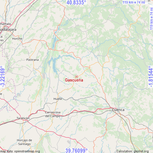
Gascueña GPS coordinates[2]
40° 17' 57.732" North, 2° 31' 6.816" West
| Map corner | latitude | longitude |
|---|---|---|
| Upper-left | 40.8335°, | -3.22169° |
| Center: | 40.29937°, | -2.51856° |
| Lower-right: | 39.76099°, | -1.81544° |
| Map W x H: | 119.3×119.3 km | = 74.1×74.1mi |
| max Lat: | 43.74134° ⇑65.8% North |
| Gascueña: | 40.29937° |
| min Lat: | ⇓34.2% South 27.64134° |
| min Long | Gascueña | max Long |
| -18.00367° | -2.51856° | 4.2899° |
| W 60.7%⇐ | ⇒39.3% E |
Elevation
Elevation of Gascueña is 931 m = 3054 ft, and this is 333 m = 1093 ft above average elevation for this country.
| Max E: |
1682 m = 5518 ft | 16.7% |
| Gascueña | 931 m 3054 ft | |
| Avg. | 598 m = 1962 ft | |
Min E: |
0 m = 0 ft | 83.3% |
See also: Spain elevation on elevation.city.
Geographical zone
Gascueña is located in North temperate zone (between Tropic of Cancer and the Arctic Circle). Distance of this Northern Tropic circle is 1875 km =1165.1 mi to South.| Distance of | km | miles | from Gascueña |
|---|---|---|---|
| North Pole | 5526.2 | 3433.8 | to North |
| Arctic Circle | 2920.3 | 1814.6 | to North |
| Tropic Cancer | 1875 | 1165.1 | to South |
| Equator | 4480.9 | 2784.3 | to South |


Nearby cities:
15 places around Gascueña: (largest is in red/bold)
• Alcohujate
15.5 km =9.6 mi,  328°
328°
• Arrancacepas
13.5 km =8.4 mi,  88°
88°
• Buciegas
6.3 km =3.9 mi,  49°
49°
• Canalejas del Arroyo
8 km =5 mi,  15°
15°
• Castillo-Albaráñez
10.7 km =6.6 mi, 90°
• Cañaveras
12.4 km =7.7 mi,  57°
57°
• Cañaveruelas
15.1 km =9.4 mi,  318°
318°
• Olmeda de la Cuesta
3.8 km =2.4 mi,  70°
70°
• Olmedilla de Eliz
8.4 km =5.2 mi, 87°
• San Pedro Palmiches
17.3 km =10.7 mi,  33°
33°
• Tinajas
6.1 km =3.8 mi,  298°
298°
• Torralba
19.8 km =12.3 mi, 88°
• Villaconejos de Trabaque
20.3 km =12.6 mi, 56°
• Villalba del Rey
11.5 km =7.1 mi, 297°
• Villar del Infantado
17.6 km =10.9 mi,  10°
10°
Sources, notices
• [Note1] Compared only with cities in Spain existing in our database
• [Src1] Map data: © OpenStreetMap contributors (CC-BY-SA)
• [Src2] Other city data from geonames.org with taken over terms of usage.
• [Src3] Geographical zone / Annual Mean Temperature by Robert A. Rohde @ Wikipedia
