Villalba del Rey geodata
Villalba del Rey (Castille-La Mancha) is a seat of a third-order administrative division; located in Spain in Europe/Madrid (GMT+2) time zone. With population of 658 people, there are 3490 cities with bigger population in this country. Compared to other cities in Spain, 65% of cities are located further ↑North; 59.4% of cities are located further ←West and 67.9% of cities have lower elevation than Villalba del Rey. Note1
Administrative division(s):
- Level 1: Castille-La Mancha
- Level 2: Provincia de Cuenca
- Level 3: Villalba del Rey


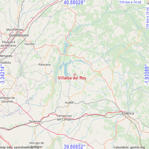
Villalba del Rey GPS coordinates[2]
40° 20' 47.508" North, 2° 38' 20.472" West
| Map corner | latitude | longitude |
|---|---|---|
| Upper-left | 40.88028°, | -3.34214° |
| Center: | 40.34653°, | -2.63902° |
| Lower-right: | 39.80852°, | -1.93589° |
| Map W x H: | 119.2×119.2 km | = 74.1×74.1mi |
| max Lat: | 43.74134° ⇑65% North |
| Villalba del Rey: | 40.34653° |
| min Lat: | ⇓35% South 27.64134° |
| min Long | Villalba del Re | max Long |
| -18.00367° | -2.63902° | 4.2899° |
| W 59.4%⇐ | ⇒40.6% E |
Elevation
Elevation of Villalba del Rey is 798 m = 2618 ft, and this is 200 m = 656 ft above average elevation for this country.
| Max E: |
1682 m = 5518 ft | 32.1% |
| Villalba del Rey | 798 m 2618 ft | |
| Avg. | 598 m = 1962 ft | |
Min E: |
0 m = 0 ft | 67.9% |
See also: Spain elevation on elevation.city.
Geographical zone
Villalba del Rey is located in North temperate zone (between Tropic of Cancer and the Arctic Circle). Distance of this Northern Tropic circle is 1880.2 km =1168.3 mi to South.| Distance of | km | miles | from Villalba del Rey |
|---|---|---|---|
| North Pole | 5520.9 | 3430.5 | to North |
| Arctic Circle | 2915.1 | 1811.4 | to North |
| Tropic Cancer | 1880.2 | 1168.3 | to South |
| Equator | 4486.1 | 2787.5 | to South |


Nearby cities:
15 places around Villalba del Rey: (largest is in red/bold)
• Albalate de Zorita
17.8 km =11.1 mi,  256°
256°
• Alcocer
13.9 km =8.6 mi,  10°
10°
• Alcohujate
8.2 km =5.1 mi, 14°
• Almonacid de Zorita
18 km =11.2 mi, 263°
• Buciegas
15 km =9.3 mi,  94°
94°
• Buendía
10.2 km =6.3 mi,  282°
282°
• Canalejas del Arroyo
12.5 km =7.8 mi,  78°
78°
• Cañaveruelas
6 km =3.7 mi,  1°
1°
• Gascueña
11.5 km =7.1 mi,  117°
117°
• Millana
18.8 km =11.7 mi,  17°
17°
• Olmeda de la Cuesta
14.4 km =8.9 mi,  105°
105°
• Sacedón
16.9 km =10.5 mi,  331°
331°
• Sayatón
18.4 km =11.4 mi, 280°
• Tinajas
5.3 km =3.3 mi, 115°
• Villar del Infantado
18.1 km =11.2 mi,  48°
48°
Sources, notices
• [Note1] Compared only with cities in Spain existing in our database
• [Src1] Map data: © OpenStreetMap contributors (CC-BY-SA)
• [Src2] Other city data from geonames.org with taken over terms of usage.
• [Src3] Geographical zone / Annual Mean Temperature by Robert A. Rohde @ Wikipedia
