Cañaveruelas geodata
Cañaveruelas (Castille-La Mancha) is a seat of a third-order administrative division; located in Spain in Europe/Madrid (GMT+2) time zone. With population of 197 people, there are 5052 cities with bigger population in this country. Compared to other cities in Spain, 64% of cities are located further ↑North; 59.4% of cities are located further ←West and 67.8% of cities have lower elevation than Cañaveruelas. Note1
Administrative division(s):
- Level 1: Castille-La Mancha
- Level 2: Provincia de Cuenca
- Level 3: Cañaveruelas


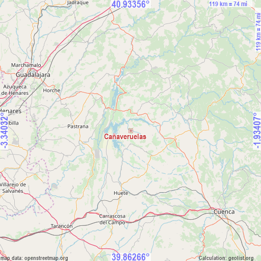
Cañaveruelas GPS coordinates[2]
40° 24' 0.864" North, 2° 38' 13.884" West
| Map corner | latitude | longitude |
|---|---|---|
| Upper-left | 40.93356°, | -3.34032° |
| Center: | 40.40024°, | -2.63719° |
| Lower-right: | 39.86266°, | -1.93407° |
| Map W x H: | 119.1×119.1 km | = 74×74mi |
| max Lat: | 43.74134° ⇑64% North |
| Cañaveruelas: | 40.40024° |
| min Lat: | ⇓36% South 27.64134° |
| min Long | Cañaveruelas | max Long |
| -18.00367° | -2.63719° | 4.2899° |
| W 59.4%⇐ | ⇒40.6% E |
Elevation
Elevation of Cañaveruelas is 797 m = 2615 ft, and this is 199 m = 653 ft above average elevation for this country.
| Max E: |
1682 m = 5518 ft | 32.2% |
| Cañaveruelas | 797 m 2615 ft | |
| Avg. | 598 m = 1962 ft | |
Min E: |
0 m = 0 ft | 67.8% |
See also: Spain elevation on elevation.city.
Geographical zone
Cañaveruelas is located in North temperate zone (between Tropic of Cancer and the Arctic Circle). Distance of this Northern Tropic circle is 1886.2 km =1172 mi to South.| Distance of | km | miles | from Cañaveruelas |
|---|---|---|---|
| North Pole | 5515 | 3426.9 | to North |
| Arctic Circle | 2909.1 | 1807.6 | to North |
| Tropic Cancer | 1886.2 | 1172 | to South |
| Equator | 4492.1 | 2791.3 | to South |


Nearby cities:
15 places around Cañaveruelas: (largest is in red/bold)
• Alcocer
8.1 km =5 mi,  16°
16°
• Alcohujate
2.7 km =1.7 mi,  44°
44°
• Buciegas
16.4 km =10.2 mi,  115°
115°
• Buendía
10.8 km =6.7 mi,  249°
249°
• Canalejas del Arroyo
12.6 km =7.8 mi,  106°
106°
• Escamilla
17.8 km =11.1 mi, 20°
• Gascueña
15.1 km =9.4 mi,  138°
138°
• Millana
13.1 km =8.1 mi,  25°
25°
• Olmeda de la Cuesta
16.9 km =10.5 mi,  126°
126°
• Pareja
17.3 km =10.7 mi,  356°
356°
• Sacedón
12.1 km =7.5 mi,  317°
317°
• Sayatón
18.4 km =11.4 mi,  261°
261°
• Tinajas
9.5 km =5.9 mi,  150°
150°
• Villalba del Rey
6 km =3.7 mi,  181°
181°
• Villar del Infantado
14.7 km =9.1 mi,  65°
65°
Sources, notices
• [Note1] Compared only with cities in Spain existing in our database
• [Src1] Map data: © OpenStreetMap contributors (CC-BY-SA)
• [Src2] Other city data from geonames.org with taken over terms of usage.
• [Src3] Geographical zone / Annual Mean Temperature by Robert A. Rohde @ Wikipedia
