Tinajas geodata
Tinajas (Castille-La Mancha) is a seat of a third-order administrative division; located in Spain in Europe/Madrid (GMT+2) time zone. With population of 369 people, there are 4239 cities with bigger population in this country. Compared to other cities in Spain, 65.3% of cities are located further ↑North; 60.1% of cities are located further ←West and 76.9% of cities have lower elevation than Tinajas. Note1
Administrative division(s):
- Level 1: Castille-La Mancha
- Level 2: Provincia de Cuenca
- Level 3: Tinajas


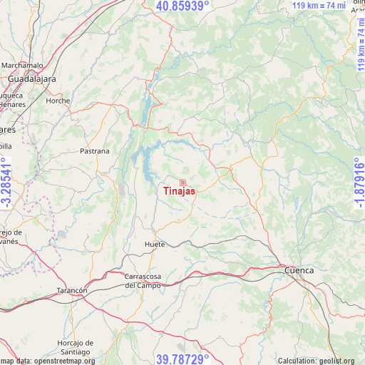
Tinajas GPS coordinates[2]
40° 19' 31.692" North, 2° 34' 56.208" West
| Map corner | latitude | longitude |
|---|---|---|
| Upper-left | 40.85939°, | -3.28541° |
| Center: | 40.32547°, | -2.58228° |
| Lower-right: | 39.78729°, | -1.87916° |
| Map W x H: | 119.2×119.2 km | = 74.1×74.1mi |
| max Lat: | 43.74134° ⇑65.3% North |
| Tinajas: | 40.32547° |
| min Lat: | ⇓34.7% South 27.64134° |
| min Long | Tinajas | max Long |
| -18.00367° | -2.58228° | 4.2899° |
| W 60.1%⇐ | ⇒39.9% E |
Elevation
Elevation of Tinajas is 870 m = 2854 ft, and this is 272 m = 892 ft above average elevation for this country.
| Max E: |
1682 m = 5518 ft | 23.1% |
| Tinajas | 870 m 2854 ft | |
| Avg. | 598 m = 1962 ft | |
Min E: |
0 m = 0 ft | 76.9% |
See also: Spain elevation on elevation.city.
Geographical zone
Tinajas is located in North temperate zone (between Tropic of Cancer and the Arctic Circle). Distance of this Northern Tropic circle is 1877.9 km =1166.9 mi to South.| Distance of | km | miles | from Tinajas |
|---|---|---|---|
| North Pole | 5523.3 | 3432 | to North |
| Arctic Circle | 2917.4 | 1812.8 | to North |
| Tropic Cancer | 1877.9 | 1166.9 | to South |
| Equator | 4483.8 | 2786.1 | to South |


Nearby cities:
15 places around Tinajas: (largest is in red/bold)
• Alcocer
16.2 km =10.1 mi,  351°
351°
• Alcohujate
10.6 km =6.6 mi,  344°
344°
• Arrancacepas
19.1 km =11.9 mi,  97°
97°
• Buciegas
10.2 km =6.3 mi,  83°
83°
• Buendía
15.4 km =9.6 mi,  287°
287°
• Canalejas del Arroyo
8.9 km =5.5 mi,  57°
57°
• Castillo-Albaráñez
16.3 km =10.1 mi, 100°
• Cañaveras
16.2 km =10.1 mi, 76°
• Cañaveruelas
9.5 km =5.9 mi,  330°
330°
• Gascueña
6.1 km =3.8 mi,  118°
118°
• Olmeda de la Cuesta
9.2 km =5.7 mi, 100°
• Olmedilla de Eliz
14 km =8.7 mi, 100°
• San Pedro Palmiches
18.9 km =11.7 mi,  52°
52°
• Villalba del Rey
5.3 km =3.3 mi,  295°
295°
• Villar del Infantado
16.9 km =10.5 mi,  31°
31°
Sources, notices
• [Note1] Compared only with cities in Spain existing in our database
• [Src1] Map data: © OpenStreetMap contributors (CC-BY-SA)
• [Src2] Other city data from geonames.org with taken over terms of usage.
• [Src3] Geographical zone / Annual Mean Temperature by Robert A. Rohde @ Wikipedia
