Gallegos de Argañán geodata
Gallegos de Argañán (Castille and León) is a seat of a third-order administrative division; located in Spain in Europe/Madrid (GMT+2) time zone. With population of 359 people, there are 4279 cities with bigger population in this country. Compared to other cities in Spain, 59.2% of cities are located further ↑North; 92.8% of cities are located further →East and 50.3% of cities have lower elevation than Gallegos de Argañán. Note1
Administrative division(s):
- Level 1: Castille and León
- Level 2: Provincia de Salamanca
- Level 3: Gallegos de Argañán


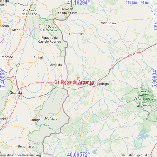
Gallegos de Argañán GPS coordinates[2]
40° 37' 53.256" North, 6° 42' 8.856" West
| Map corner | latitude | longitude |
|---|---|---|
| Upper-left | 41.16294°, | -7.40559° |
| Center: | 40.63146°, | -6.70246° |
| Lower-right: | 40.09572°, | -5.99934° |
| Map W x H: | 118.7×118.7 km | = 73.8×73.8mi |
| max Lat: | 43.74134° ⇑59.2% North |
| Gallegos de Argañán: | 40.63146° |
| min Lat: | ⇓40.8% South 27.64134° |
| min Long | Gallegos de Arg | max Long |
| -18.00367° | -6.70246° | 4.2899° |
| W 7.2%⇐ | ⇒92.8% E |
Elevation
Elevation of Gallegos de Argañán is 662 m = 2172 ft, and this is 64 m = 210 ft above average elevation for this country.
| Max E: |
1682 m = 5518 ft | 49.7% |
| Gallegos de Argañán | 662 m 2172 ft | |
| Avg. | 598 m = 1962 ft | |
Min E: |
0 m = 0 ft | 50.3% |
See also: Spain elevation on elevation.city.
Geographical zone
Gallegos de Argañán is located in North temperate zone (between Tropic of Cancer and the Arctic Circle). Distance of this Northern Tropic circle is 1911.9 km =1188 mi to South.| Distance of | km | miles | from Gallegos de Argañán |
|---|---|---|---|
| North Pole | 5489.3 | 3410.9 | to North |
| Arctic Circle | 2883.4 | 1791.7 | to North |
| Tropic Cancer | 1911.9 | 1188 | to South |
| Equator | 4517.8 | 2807.2 | to South |


Nearby cities:
15 places around Gallegos de Argañán: (largest is in red/bold)
• Aldea del Obispo
11.3 km =7 mi,  317°
317°
• Campillo de Azaba
13.6 km =8.5 mi,  174°
174°
• Carpio de Azaba
6.1 km =3.8 mi,  129°
129°
• Castillejo de Martín Viejo
9.1 km =5.7 mi,  36°
36°
• Ciudad Rodrigo
14.7 km =9.1 mi,  103°
103°
• Espeja
7.4 km =4.6 mi,  188°
188°
• Fuenteguinaldo
22.7 km =14.1 mi, 174°
• Fuentes de Oñoro
10.2 km =6.3 mi,  243°
243°
• Ituero de Azaba
16.3 km =10.1 mi,  177°
177°
• Pastores
20.8 km =12.9 mi, 128°
• Puebla de Azaba
20.8 km =12.9 mi, 190°
• Puerto Seguro
22.3 km =13.9 mi,  347°
347°
• Saelices el Chico
7.3 km =4.5 mi,  53°
53°
• Villar de Ciervo
12.2 km =7.6 mi, 345°
• Villar de la Yegua
10.5 km =6.5 mi,  359°
359°
Sources, notices
• [Note1] Compared only with cities in Spain existing in our database
• [Src1] Map data: © OpenStreetMap contributors (CC-BY-SA)
• [Src2] Other city data from geonames.org with taken over terms of usage.
• [Src3] Geographical zone / Annual Mean Temperature by Robert A. Rohde @ Wikipedia
