Espeja geodata
Espeja (Castille and León) is a seat of a third-order administrative division; located in Spain in Europe/Madrid (GMT+2) time zone. With population of 272 people, there are 4621 cities with bigger population in this country. Compared to other cities in Spain, 60.5% of cities are located further ↑North; 92.9% of cities are located further →East and 53.9% of cities have lower elevation than Espeja. Note1
Administrative division(s):
- Level 1: Castille and León
- Level 2: Provincia de Salamanca
- Level 3: Espeja


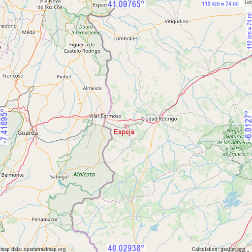
Espeja GPS coordinates[2]
40° 33' 56.34" North, 6° 42' 56.952" West
| Map corner | latitude | longitude |
|---|---|---|
| Upper-left | 41.09765°, | -7.41895° |
| Center: | 40.56565°, | -6.71582° |
| Lower-right: | 40.02938°, | -6.0127° |
| Map W x H: | 118.8×118.8 km | = 73.8×73.8mi |
| max Lat: | 43.74134° ⇑60.5% North |
| Espeja: | 40.56565° |
| min Lat: | ⇓39.5% South 27.64134° |
| min Long | Espeja | max Long |
| -18.00367° | -6.71582° | 4.2899° |
| W 7.1%⇐ | ⇒92.9% E |
Elevation
Elevation of Espeja is 699 m = 2293 ft, and this is 101 m = 331 ft above average elevation for this country.
| Max E: |
1682 m = 5518 ft | 46.1% |
| Espeja | 699 m 2293 ft | |
| Avg. | 598 m = 1962 ft | |
Min E: |
0 m = 0 ft | 53.9% |
See also: Spain elevation on elevation.city.
Geographical zone
Espeja is located in North temperate zone (between Tropic of Cancer and the Arctic Circle). Distance of this Northern Tropic circle is 1904.6 km =1183.5 mi to South.| Distance of | km | miles | from Espeja |
|---|---|---|---|
| North Pole | 5496.6 | 3415.4 | to North |
| Arctic Circle | 2890.7 | 1796.2 | to North |
| Tropic Cancer | 1904.6 | 1183.5 | to South |
| Equator | 4510.5 | 2802.7 | to South |


Nearby cities:
15 places around Espeja: (largest is in red/bold)
• Aldea del Obispo
17 km =10.6 mi,  337°
337°
• Campillo de Azaba
6.7 km =4.2 mi,  158°
158°
• Carpio de Azaba
6.7 km =4.2 mi,  59°
59°
• Castillejo de Martín Viejo
16.1 km =10 mi,  24°
24°
• Ciudad Rodrigo
15.9 km =9.9 mi,  76°
76°
• Fuenteguinaldo
15.6 km =9.7 mi,  167°
167°
• Fuentes de Oñoro
8.6 km =5.3 mi,  289°
289°
• Gallegos de Argañán
7.4 km =4.6 mi,  8°
8°
• Herguijuela de Ciudad Rodrigo
20.3 km =12.6 mi,  125°
125°
• Ituero de Azaba
9.2 km =5.7 mi, 167°
• Pastores
18.3 km =11.4 mi,  107°
107°
• Puebla de Azaba
13.4 km =8.3 mi,  191°
191°
• Saelices el Chico
13.6 km =8.5 mi,  31°
31°
• Villar de Ciervo
19.2 km =11.9 mi,  354°
354°
• Villar de la Yegua
17.8 km =11.1 mi,  3°
3°
Sources, notices
• [Note1] Compared only with cities in Spain existing in our database
• [Src1] Map data: © OpenStreetMap contributors (CC-BY-SA)
• [Src2] Other city data from geonames.org with taken over terms of usage.
• [Src3] Geographical zone / Annual Mean Temperature by Robert A. Rohde @ Wikipedia
