Puebla de Azaba geodata
Puebla de Azaba (Castille and León) is a seat of a third-order administrative division; located in Spain in Europe/Madrid (GMT+2) time zone. With population of 253 people, there are 4727 cities with bigger population in this country. Compared to other cities in Spain, 63% of cities are located further ↑North; 93.1% of cities are located further →East and 51.2% of cities have lower elevation than Puebla de Azaba. Note1
Administrative division(s):
- Level 1: Castille and León
- Level 2: Provincia de Salamanca
- Level 3: Puebla de Azaba


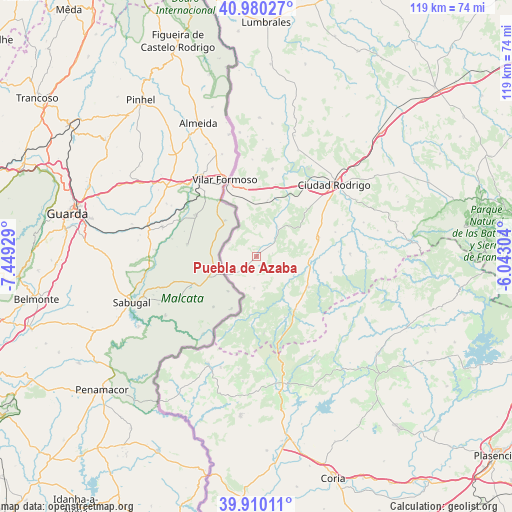
Puebla de Azaba GPS coordinates[2]
40° 26' 50.352" North, 6° 44' 46.176" West
| Map corner | latitude | longitude |
|---|---|---|
| Upper-left | 40.98027°, | -7.44929° |
| Center: | 40.44732°, | -6.74616° |
| Lower-right: | 39.91011°, | -6.04304° |
| Map W x H: | 119×119 km | = 73.9×73.9mi |
| max Lat: | 43.74134° ⇑63% North |
| Puebla de Azaba: | 40.44732° |
| min Lat: | ⇓37% South 27.64134° |
| min Long | Puebla de Azaba | max Long |
| -18.00367° | -6.74616° | 4.2899° |
| W 6.9%⇐ | ⇒93.1% E |
Elevation
Elevation of Puebla de Azaba is 672 m = 2205 ft, and this is 74 m = 243 ft above average elevation for this country.
| Max E: |
1682 m = 5518 ft | 48.8% |
| Puebla de Azaba | 672 m 2205 ft | |
| Avg. | 598 m = 1962 ft | |
Min E: |
0 m = 0 ft | 51.2% |
See also: Spain elevation on elevation.city.
Geographical zone
Puebla de Azaba is located in North temperate zone (between Tropic of Cancer and the Arctic Circle). Distance of this Northern Tropic circle is 1891.4 km =1175.3 mi to South.| Distance of | km | miles | from Puebla de Azaba |
|---|---|---|---|
| North Pole | 5509.7 | 3423.6 | to North |
| Arctic Circle | 2903.9 | 1804.4 | to North |
| Tropic Cancer | 1891.4 | 1175.3 | to South |
| Equator | 4497.3 | 2794.5 | to South |


Nearby cities:
15 places around Puebla de Azaba: (largest is in red/bold)
• Campillo de Azaba
8.5 km =5.3 mi,  35°
35°
• Carpio de Azaba
18.5 km =11.5 mi,  26°
26°
• Casillas de Flores
7.4 km =4.6 mi,  186°
186°
• Espeja
13.4 km =8.3 mi,  11°
11°
• Fuenteguinaldo
6.3 km =3.9 mi,  108°
108°
• Fuentes de Oñoro
16.9 km =10.5 mi,  340°
340°
• Gallegos de Argañán
20.8 km =12.9 mi, 10°
• Herguijuela de Ciudad Rodrigo
19.1 km =11.9 mi,  86°
86°
• Ituero de Azaba
6.2 km =3.9 mi,  47°
47°
• Martiago
21.7 km =13.5 mi, 87°
• Navasfrías
17.9 km =11.1 mi,  200°
200°
• Pastores
21.3 km =13.2 mi,  69°
69°
• Peñaparda
15.5 km =9.6 mi,  155°
155°
• Robleda
13.7 km =8.5 mi,  120°
120°
• Villasrubias
15.1 km =9.4 mi,  143°
143°
Sources, notices
• [Note1] Compared only with cities in Spain existing in our database
• [Src1] Map data: © OpenStreetMap contributors (CC-BY-SA)
• [Src2] Other city data from geonames.org with taken over terms of usage.
• [Src3] Geographical zone / Annual Mean Temperature by Robert A. Rohde @ Wikipedia
