Irueste geodata
Irueste (Castille-La Mancha) is a seat of a third-order administrative division; located in Spain in Europe/Madrid (GMT+2) time zone. With population of 61 people, there are 6339 cities with bigger population in this country. Compared to other cities in Spain, 59.6% of cities are located further ↑North; 56% of cities are located further ←West and 75.1% of cities have lower elevation than Irueste. Note1
Administrative division(s):
- Level 1: Castille-La Mancha
- Level 2: Provincia de Guadalajara
- Level 3: Irueste


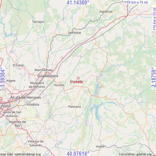
Irueste GPS coordinates[2]
40° 36' 43.416" North, 2° 53' 26.592" West
| Map corner | latitude | longitude |
|---|---|---|
| Upper-left | 41.14369°, | -3.59384° |
| Center: | 40.61206°, | -2.89072° |
| Lower-right: | 40.07616°, | -2.18759° |
| Map W x H: | 118.7×118.7 km | = 73.8×73.8mi |
| max Lat: | 43.74134° ⇑59.6% North |
| Irueste: | 40.61206° |
| min Lat: | ⇓40.4% South 27.64134° |
| min Long | Irueste | max Long |
| -18.00367° | -2.89072° | 4.2899° |
| W 56%⇐ | ⇒44% E |
Elevation
Elevation of Irueste is 852 m = 2795 ft, and this is 254 m = 833 ft above average elevation for this country.
| Max E: |
1682 m = 5518 ft | 24.9% |
| Irueste | 852 m 2795 ft | |
| Avg. | 598 m = 1962 ft | |
Min E: |
0 m = 0 ft | 75.1% |
See also: Spain elevation on elevation.city.
Geographical zone
Irueste is located in North temperate zone (between Tropic of Cancer and the Arctic Circle). Distance of this Northern Tropic circle is 1909.7 km =1186.6 mi to South.| Distance of | km | miles | from Irueste |
|---|---|---|---|
| North Pole | 5491.4 | 3412.2 | to North |
| Arctic Circle | 2885.5 | 1793 | to North |
| Tropic Cancer | 1909.7 | 1186.6 | to South |
| Equator | 4515.6 | 2805.9 | to South |


Nearby cities:
15 places around Irueste: (largest is in red/bold)
• Alhóndiga
11 km =6.8 mi,  149°
149°
• Atanzón
10.8 km =6.7 mi,  304°
304°
• Berninches
8.8 km =5.5 mi,  121°
121°
• Budia
11.3 km =7 mi,  81°
81°
• Caspueñas
11.9 km =7.4 mi,  320°
320°
• Fuentelencina
10.5 km =6.5 mi,  176°
176°
• Fuentelviejo
12.4 km =7.7 mi,  219°
219°
• Peñalver
3.4 km =2.1 mi, 177°
• Romanones
9.6 km =6 mi,  241°
241°
• San Andrés del Rey
6.6 km =4.1 mi,  63°
63°
• Tendilla
9.5 km =5.9 mi, 216°
• Valdeavellano
8.9 km =5.5 mi,  311°
311°
• Valfermoso de Tajuña
5.4 km =3.4 mi,  278°
278°
• Yélamos de Abajo
3.5 km =2.2 mi,  52°
52°
• Yélamos de Arriba
5.1 km =3.2 mi, 52°
Sources, notices
• [Note1] Compared only with cities in Spain existing in our database
• [Src1] Map data: © OpenStreetMap contributors (CC-BY-SA)
• [Src2] Other city data from geonames.org with taken over terms of usage.
• [Src3] Geographical zone / Annual Mean Temperature by Robert A. Rohde @ Wikipedia
