Alhóndiga geodata
Alhóndiga (Castille-La Mancha) is a seat of a third-order administrative division; located in Spain in Europe/Madrid (GMT+2) time zone. With population of 242 people, there are 4797 cities with bigger population in this country. Compared to other cities in Spain, 61.3% of cities are located further ↑North; 57.1% of cities are located further ←West and 72.7% of cities have lower elevation than Alhóndiga. Note1
Administrative division(s):
- Level 1: Castille-La Mancha
- Level 2: Provincia de Guadalajara
- Level 3: Alhóndiga


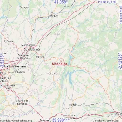
Alhóndiga GPS coordinates[2]
40° 31' 36.084" North, 2° 49' 27.768" West
| Map corner | latitude | longitude |
|---|---|---|
| Upper-left | 41.059°, | -3.5275° |
| Center: | 40.52669°, | -2.82438° |
| Lower-right: | 39.99011°, | -2.12125° |
| Map W x H: | 118.8×118.8 km | = 73.8×73.8mi |
| max Lat: | 43.74134° ⇑61.3% North |
| Alhóndiga: | 40.52669° |
| min Lat: | ⇓38.7% South 27.64134° |
| min Long | Alhóndiga | max Long |
| -18.00367° | -2.82438° | 4.2899° |
| W 57.1%⇐ | ⇒42.9% E |
Elevation
Elevation of Alhóndiga is 832 m = 2730 ft, and this is 234 m = 768 ft above average elevation for this country.
| Max E: |
1682 m = 5518 ft | 27.3% |
| Alhóndiga | 832 m 2730 ft | |
| Avg. | 598 m = 1962 ft | |
Min E: |
0 m = 0 ft | 72.7% |
See also: Spain elevation on elevation.city.
Geographical zone
Alhóndiga is located in North temperate zone (between Tropic of Cancer and the Arctic Circle). Distance of this Northern Tropic circle is 1900.2 km =1180.7 mi to South.| Distance of | km | miles | from Alhóndiga |
|---|---|---|---|
| North Pole | 5500.9 | 3418.1 | to North |
| Arctic Circle | 2895 | 1798.9 | to North |
| Tropic Cancer | 1900.2 | 1180.7 | to South |
| Equator | 4506.1 | 2800 | to South |


Nearby cities:
15 places around Alhóndiga: (largest is in red/bold)
• Alocén
8.2 km =5.1 mi,  49°
49°
• Auñón
2.9 km =1.8 mi,  110°
110°
• Berninches
5.3 km =3.3 mi,  21°
21°
• Budia
12.5 km =7.8 mi,  26°
26°
• Fuentelencina
5 km =3.1 mi,  258°
258°
• Fuentelviejo
13.5 km =8.4 mi,  269°
269°
• Irueste
11 km =6.8 mi,  329°
329°
• Moratilla de los Meleros
10.4 km =6.5 mi,  254°
254°
• Peñalver
8.2 km =5.1 mi,  318°
318°
• Sacedón
9.2 km =5.7 mi,  123°
123°
• San Andrés del Rey
12.4 km =7.7 mi,  1°
1°
• Tendilla
11.4 km =7.1 mi,  279°
279°
• Valdeconcha
9 km =5.6 mi,  209°
209°
• Yélamos de Abajo
11.9 km =7.4 mi,  346°
346°
• Yélamos de Arriba
12.7 km =7.9 mi, 352°
Sources, notices
• [Note1] Compared only with cities in Spain existing in our database
• [Src1] Map data: © OpenStreetMap contributors (CC-BY-SA)
• [Src2] Other city data from geonames.org with taken over terms of usage.
• [Src3] Geographical zone / Annual Mean Temperature by Robert A. Rohde @ Wikipedia
