Frías geodata
Frías (Castille and León) is a seat of a third-order administrative division; located in Spain in Europe/Madrid (GMT+2) time zone. With population of 354 people, there are 4302 cities with bigger population in this country. Compared to other cities in Spain, 92.2% of cities are located further ↓South; 50.5% of cities are located further ←West and 55.9% of cities have higher elevation than Frías. Note1


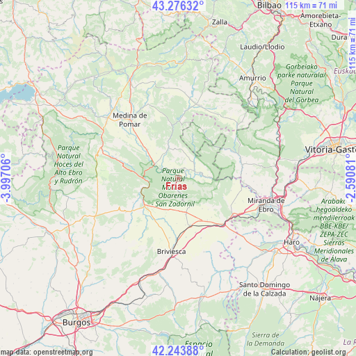
Frías GPS coordinates[2]
42° 45' 44.1" North, 3° 17' 38.184" West
| Map corner | latitude | longitude |
|---|---|---|
| Upper-left | 43.27632°, | -3.99706° |
| Center: | 42.76225°, | -3.29394° |
| Lower-right: | 42.24388°, | -2.59081° |
| Map W x H: | 114.8×114.8 km | = 71.3×71.3mi |
| max Lat: | 43.74134° ⇑7.8% North |
| Frías: | 42.76225° |
| min Lat: | ⇓92.2% South 27.64134° |
| min Long | Frías | max Long |
| -18.00367° | -3.29394° | 4.2899° |
| W 50.5%⇐ | ⇒49.5% E |
Elevation
Elevation of Frías is 583 m = 1913 ft, and this is 15 m = 49 ft below average elevation for this country.
| Max E: |
1682 m = 5518 ft | 55.9% |
| Avg. | 598 m = 1962 ft | |
| Frías | 583 m = 1913 ft | |
Min E: |
0 m = 0 ft | 44.1% |
See also: Spain elevation on elevation.city.
Geographical zone
Frías is located in North temperate zone (between Tropic of Cancer and the Arctic Circle). Distance of this Northern Tropic circle is 2148.8 km =1335.2 mi to South.| Distance of | km | miles | from Frías |
|---|---|---|---|
| North Pole | 5252.3 | 3263.6 | to North |
| Arctic Circle | 2646.5 | 1644.5 | to North |
| Tropic Cancer | 2148.8 | 1335.2 | to South |
| Equator | 4754.7 | 2954.4 | to South |


Nearby cities:
15 places around Frías: (largest is in red/bold)
• Berzosa de Bureba
15.2 km =9.4 mi,  171°
171°
• Busto de Bureba
11.7 km =7.3 mi, 168°
• Cantabrana
14.5 km =9 mi,  257°
257°
• Cascajares de Bureba
10.4 km =6.5 mi,  153°
153°
• Cubo de Bureba
15.4 km =9.6 mi, 152°
• Fuentebureba
15 km =9.3 mi,  161°
161°
• Miraveche
12.5 km =7.8 mi,  141°
141°
• Navas de Bureba
9.4 km =5.8 mi,  196°
196°
• Oña
10.3 km =6.4 mi,  252°
252°
• Quintanaélez
10.4 km =6.5 mi,  182°
182°
• Salas de Bureba
16.6 km =10.3 mi,  241°
241°
• Trespaderne
9 km =5.6 mi,  299°
299°
• Vileña
15.7 km =9.8 mi,  188°
188°
• Villanueva de Teba
16.5 km =10.3 mi, 139°
• Zuñeda
18.3 km =11.4 mi, 162°
Sources, notices
• [Note1] Compared only with cities in Spain existing in our database
• [Src1] Map data: © OpenStreetMap contributors (CC-BY-SA)
• [Src2] Other city data from geonames.org with taken over terms of usage.
• [Src3] Geographical zone / Annual Mean Temperature by Robert A. Rohde @ Wikipedia
