Cantabrana geodata
Cantabrana (Castille and León) is a seat of a third-order administrative division; located in Spain in Europe/Madrid (GMT+2) time zone. With population of 37 people, there are 6601 cities with bigger population in this country. Compared to other cities in Spain, 92% of cities are located further ↓South; 51.6% of cities are located further →East and 52.1% of cities have higher elevation than Cantabrana. Note1
Administrative division(s):
- Level 1: Castille and León
- Level 2: Provincia de Burgos
- Level 3: Cantabrana


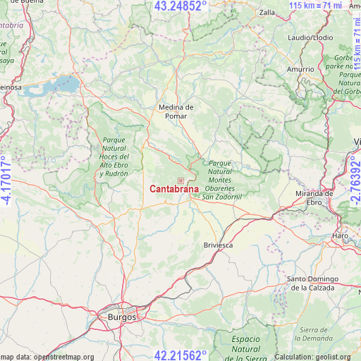
Cantabrana GPS coordinates[2]
42° 44' 3.192" North, 3° 28' 1.344" West
| Map corner | latitude | longitude |
|---|---|---|
| Upper-left | 43.24852°, | -4.17017° |
| Center: | 42.73422°, | -3.46704° |
| Lower-right: | 42.21562°, | -2.76392° |
| Map W x H: | 114.8×114.8 km | = 71.3×71.3mi |
| max Lat: | 43.74134° ⇑8% North |
| Cantabrana: | 42.73422° |
| min Lat: | ⇓92% South 27.64134° |
| min Long | Cantabrana | max Long |
| -18.00367° | -3.46704° | 4.2899° |
| W 48.4%⇐ | ⇒51.6% E |
Elevation
Elevation of Cantabrana is 635 m = 2083 ft, and this is 37 m = 121 ft above average elevation for this country.
| Max E: |
1682 m = 5518 ft | 52.1% |
| Cantabrana | 635 m 2083 ft | |
| Avg. | 598 m = 1962 ft | |
Min E: |
0 m = 0 ft | 47.9% |
See also: Spain elevation on elevation.city.
Geographical zone
Cantabrana is located in North temperate zone (between Tropic of Cancer and the Arctic Circle). Distance of this Northern Tropic circle is 2145.7 km =1333.3 mi to South.| Distance of | km | miles | from Cantabrana |
|---|---|---|---|
| North Pole | 5255.5 | 3265.6 | to North |
| Arctic Circle | 2649.6 | 1646.4 | to North |
| Tropic Cancer | 2145.7 | 1333.3 | to South |
| Equator | 4751.6 | 2952.5 | to South |


Nearby cities:
15 places around Cantabrana: (largest is in red/bold)
• Abajas
15.5 km =9.6 mi,  216°
216°
• Carcedo de Bureba
17.5 km =10.9 mi,  188°
188°
• Frías
14.5 km =9 mi,  77°
77°
• Llano de Bureba
12.2 km =7.6 mi,  176°
176°
• Navas de Bureba
12.9 km =8 mi,  117°
117°
• Oña
4.3 km =2.7 mi,  90°
90°
• Padrones de Bureba
6.2 km =3.9 mi,  239°
239°
• Piérnigas
16.6 km =10.3 mi,  164°
164°
• Poza de la Sal
8.1 km =5 mi,  200°
200°
• Quintanaélez
15.5 km =9.6 mi, 117°
• Rojas
17.5 km =10.9 mi,  173°
173°
• Rucandio
6.4 km =4 mi,  287°
287°
• Salas de Bureba
4.7 km =2.9 mi, 186°
• Trespaderne
9.8 km =6.1 mi,  39°
39°
• Vileña
17.1 km =10.6 mi,  136°
136°
Sources, notices
• [Note1] Compared only with cities in Spain existing in our database
• [Src1] Map data: © OpenStreetMap contributors (CC-BY-SA)
• [Src2] Other city data from geonames.org with taken over terms of usage.
• [Src3] Geographical zone / Annual Mean Temperature by Robert A. Rohde @ Wikipedia
