Genevilla geodata
Genevilla (Navarre) is a seat of a third-order administrative division; located in Spain in Europe/Madrid (GMT+2) time zone. With population of 100 people, there are 5934 cities with bigger population in this country. Compared to other cities in Spain, 90.5% of cities are located further ↓South; 62.4% of cities are located further ←West and 52.7% of cities have higher elevation than Genevilla. Note1


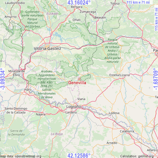
Genevilla GPS coordinates[2]
42° 38' 42.72" North, 2° 23' 24.756" West
| Map corner | latitude | longitude |
|---|---|---|
| Upper-left | 43.16024°, | -3.09334° |
| Center: | 42.6452°, | -2.39021° |
| Lower-right: | 42.12586°, | -1.68709° |
| Map W x H: | 115×115 km | = 71.5×71.5mi |
| max Lat: | 43.74134° ⇑9.5% North |
| Genevilla: | 42.6452° |
| min Lat: | ⇓90.5% South 27.64134° |
| min Long | Genevilla | max Long |
| -18.00367° | -2.39021° | 4.2899° |
| W 62.4%⇐ | ⇒37.6% E |
Elevation
Elevation of Genevilla is 626 m = 2054 ft, and this is 28 m = 92 ft above average elevation for this country.
| Max E: |
1682 m = 5518 ft | 52.7% |
| Genevilla | 626 m 2054 ft | |
| Avg. | 598 m = 1962 ft | |
Min E: |
0 m = 0 ft | 47.3% |
See also: Spain elevation on elevation.city.
Geographical zone
Genevilla is located in North temperate zone (between Tropic of Cancer and the Arctic Circle). Distance of this Northern Tropic circle is 2135.8 km =1327.1 mi to South.| Distance of | km | miles | from Genevilla |
|---|---|---|---|
| North Pole | 5265.4 | 3271.8 | to North |
| Arctic Circle | 2659.5 | 1652.5 | to North |
| Tropic Cancer | 2135.8 | 1327.1 | to South |
| Equator | 4741.7 | 2946.4 | to South |


Nearby cities:
15 places around Genevilla: (largest is in red/bold)
• Aguilar de Codés
3.6 km =2.2 mi,  179°
179°
• Aras
9.7 km =6 mi,  163°
163°
• Armañanzas
12.8 km =8 mi,  137°
137°
• Azuelo
5.3 km =3.3 mi, 141°
• Bargota
11.5 km =7.1 mi,  145°
145°
• Bernedo
9 km =5.6 mi,  256°
256°
• Cabredo
2.4 km =1.5 mi,  224°
224°
• Desojo
11.4 km =7.1 mi,  123°
123°
• Espronceda
8.8 km =5.5 mi,  127°
127°
• Lapoblación
7.3 km =4.5 mi,  231°
231°
• Marañón
4.4 km =2.7 mi,  246°
246°
• Mirafuentes
9.4 km =5.8 mi,  105°
105°
• Moreda Araba / Moreda de Álava
13.4 km =8.3 mi,  186°
186°
• Nazar
9.1 km =5.7 mi,  95°
95°
• Zúñiga
9.1 km =5.7 mi,  54°
54°
Sources, notices
• [Note1] Compared only with cities in Spain existing in our database
• [Src1] Map data: © OpenStreetMap contributors (CC-BY-SA)
• [Src2] Other city data from geonames.org with taken over terms of usage.
• [Src3] Geographical zone / Annual Mean Temperature by Robert A. Rohde @ Wikipedia
