Épila geodata
Épila (Aragon) is a seat of a third-order administrative division; located in Spain in Europe/Madrid (GMT+2) time zone. With population of 4,114 people, there are 1451 cities with bigger population in this country. Compared to other cities in Spain, 63.4% of cities are located further ↓South; 74.9% of cities are located further ←West and 73% of cities have higher elevation than Épila. Note1


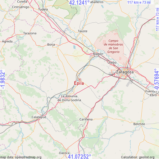
Épila GPS coordinates[2]
41° 36' 1.62" North, 1° 16' 48.252" West
| Map corner | latitude | longitude |
|---|---|---|
| Upper-left | 42.1241°, | -1.9832° |
| Center: | 41.60045°, | -1.28007° |
| Lower-right: | 41.07252°, | -0.57694° |
| Map W x H: | 116.9×116.9 km | = 72.6×72.6mi |
| max Lat: | 43.74134° ⇑36.6% North |
| Épila: | 41.60045° |
| min Lat: | ⇓63.4% South 27.64134° |
| min Long | Épila | max Long |
| -18.00367° | -1.28007° | 4.2899° |
| W 74.9%⇐ | ⇒25.1% E |
Elevation
Elevation of Épila is 331 m = 1086 ft, and this is 267 m = 876 ft below average elevation for this country.
| Max E: |
1682 m = 5518 ft | 73% |
| Avg. | 598 m = 1962 ft | |
| Épila | 331 m = 1086 ft | |
Min E: |
0 m = 0 ft | 27% |
See also: Spain elevation on elevation.city.
Geographical zone
Épila is located in North temperate zone (between Tropic of Cancer and the Arctic Circle). Distance of this Northern Tropic circle is 2019.6 km =1254.9 mi to South.| Distance of | km | miles | from Épila |
|---|---|---|---|
| North Pole | 5381.5 | 3343.9 | to North |
| Arctic Circle | 2775.6 | 1724.7 | to North |
| Tropic Cancer | 2019.6 | 1254.9 | to South |
| Equator | 4625.5 | 2874.2 | to South |


Nearby cities:
15 places around Épila: (largest is in red/bold)
• Alfamén
18.2 km =11.3 mi,  170°
170°
• Bardallur
10.9 km =6.8 mi,  31°
31°
• Bárboles
14.4 km =8.9 mi, 32°
• Calatorao
10.3 km =6.4 mi,  212°
212°
• Chodes
20.9 km =13 mi,  232°
232°
• Figueruelas
20.4 km =12.7 mi, 25°
• Grisén
18.8 km =11.7 mi, 31°
• La Almunia de Doña Godina
15.8 km =9.8 mi, 209°
• Lucena de Jalón
5.9 km =3.7 mi, 207°
• Lumpiaque
3.7 km =2.3 mi,  331°
331°
• Plasencia de Jalón
9.9 km =6.2 mi,  24°
24°
• Pleitas
13.9 km =8.6 mi, 27°
• Ricla
14.8 km =9.2 mi,  224°
224°
• Salillas de Jalón
5.1 km =3.2 mi, 224°
• Urrea de Jalón
8.3 km =5.2 mi, 27°
Sources, notices
• [Note1] Compared only with cities in Spain existing in our database
• [Src1] Map data: © OpenStreetMap contributors (CC-BY-SA)
• [Src2] Other city data from geonames.org with taken over terms of usage.
• [Src3] Geographical zone / Annual Mean Temperature by Robert A. Rohde @ Wikipedia
