Alfamén geodata
Alfamén (Aragon) is a seat of a third-order administrative division; located in Spain in Europe/Madrid (GMT+2) time zone. With population of 1,523 people, there are 2449 cities with bigger population in this country. Compared to other cities in Spain, 59.2% of cities are located further ↓South; 75.3% of cities are located further ←West and 65.7% of cities have higher elevation than Alfamén. Note1


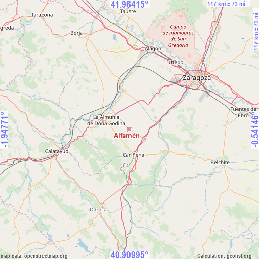
Alfamén GPS coordinates[2]
41° 26' 21.084" North, 1° 14' 40.488" West
| Map corner | latitude | longitude |
|---|---|---|
| Upper-left | 41.96415°, | -1.94771° |
| Center: | 41.43919°, | -1.24458° |
| Lower-right: | 40.90995°, | -0.54146° |
| Map W x H: | 117.2×117.2 km | = 72.8×72.8mi |
| max Lat: | 43.74134° ⇑40.8% North |
| Alfamén: | 41.43919° |
| min Lat: | ⇓59.2% South 27.64134° |
| min Long | Alfamén | max Long |
| -18.00367° | -1.24458° | 4.2899° |
| W 75.3%⇐ | ⇒24.7% E |
Elevation
Elevation of Alfamén is 450 m = 1476 ft, and this is 148 m = 486 ft below average elevation for this country.
| Max E: |
1682 m = 5518 ft | 65.7% |
| Avg. | 598 m = 1962 ft | |
| Alfamén | 450 m = 1476 ft | |
Min E: |
0 m = 0 ft | 34.3% |
See also: Spain elevation on elevation.city.
Geographical zone
Alfamén is located in North temperate zone (between Tropic of Cancer and the Arctic Circle). Distance of this Northern Tropic circle is 2001.7 km =1243.8 mi to South.| Distance of | km | miles | from Alfamén |
|---|---|---|---|
| North Pole | 5399.5 | 3355.1 | to North |
| Arctic Circle | 2793.6 | 1735.9 | to North |
| Tropic Cancer | 2001.7 | 1243.8 | to South |
| Equator | 4607.6 | 2863 | to South |


Nearby cities:
15 places around Alfamén: (largest is in red/bold)
• Aguarón
11.3 km =7 mi,  191°
191°
• Almonacid de la Sierra
8.1 km =5 mi,  235°
235°
• Alpartir
11.5 km =7.1 mi,  260°
260°
• Calatorao
12.6 km =7.8 mi,  317°
317°
• Cariñena
11.4 km =7.1 mi,  171°
171°
• Cosuenda
9.3 km =5.8 mi,  208°
208°
• La Almunia de Doña Godina
11.6 km =7.2 mi,  291°
291°
• Longares
7.5 km =4.7 mi,  122°
122°
• Lucena de Jalón
13.9 km =8.6 mi,  335°
335°
• Mezalocha
13.6 km =8.5 mi,  96°
96°
• Mozota
15.5 km =9.6 mi,  71°
71°
• Muel
13.6 km =8.5 mi,  77°
77°
• Ricla
15.3 km =9.5 mi,  299°
299°
• Salillas de Jalón
15.7 km =9.8 mi, 335°
• Tobed
17.1 km =10.6 mi,  229°
229°
Sources, notices
• [Note1] Compared only with cities in Spain existing in our database
• [Src1] Map data: © OpenStreetMap contributors (CC-BY-SA)
• [Src2] Other city data from geonames.org with taken over terms of usage.
• [Src3] Geographical zone / Annual Mean Temperature by Robert A. Rohde @ Wikipedia
