Calatorao geodata
Calatorao (Aragon) is a seat of a third-order administrative division; located in Spain in Europe/Madrid (GMT+2) time zone. With population of 3,047 people, there are 1709 cities with bigger population in this country. Compared to other cities in Spain, 61.3% of cities are located further ↓South; 74.3% of cities are located further ←West and 71.5% of cities have higher elevation than Calatorao. Note1


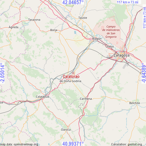
Calatorao GPS coordinates[2]
41° 31' 20.208" North, 1° 20' 49.272" West
| Map corner | latitude | longitude |
|---|---|---|
| Upper-left | 42.04657°, | -2.05014° |
| Center: | 41.52228°, | -1.34702° |
| Lower-right: | 40.99371°, | -0.64389° |
| Map W x H: | 117.1×117.1 km | = 72.8×72.8mi |
| max Lat: | 43.74134° ⇑38.7% North |
| Calatorao: | 41.52228° |
| min Lat: | ⇓61.3% South 27.64134° |
| min Long | Calatorao | max Long |
| -18.00367° | -1.34702° | 4.2899° |
| W 74.3%⇐ | ⇒25.7% E |
Elevation
Elevation of Calatorao is 356 m = 1168 ft, and this is 242 m = 794 ft below average elevation for this country.
| Max E: |
1682 m = 5518 ft | 71.5% |
| Avg. | 598 m = 1962 ft | |
| Calatorao | 356 m = 1168 ft | |
Min E: |
0 m = 0 ft | 28.5% |
See also: Spain elevation on elevation.city.
Geographical zone
Calatorao is located in North temperate zone (between Tropic of Cancer and the Arctic Circle). Distance of this Northern Tropic circle is 2010.9 km =1249.5 mi to South.| Distance of | km | miles | from Calatorao |
|---|---|---|---|
| North Pole | 5390.2 | 3349.3 | to North |
| Arctic Circle | 2784.3 | 1730.1 | to North |
| Tropic Cancer | 2010.9 | 1249.5 | to South |
| Equator | 4616.8 | 2868.7 | to South |


Nearby cities:
15 places around Calatorao: (largest is in red/bold)
• Alfamén
12.6 km =7.8 mi,  137°
137°
• Almonacid de la Sierra
14 km =8.7 mi,  172°
172°
• Alpartir
11.4 km =7.1 mi,  194°
194°
• Arándiga
12.9 km =8 mi,  263°
263°
• Chodes
11.8 km =7.3 mi,  250°
250°
• El Frasno
17.3 km =10.7 mi,  225°
225°
• La Almunia de Doña Godina
5.6 km =3.5 mi,  204°
204°
• Lucena de Jalón
4.4 km =2.7 mi,  39°
39°
• Lumpiaque
12.5 km =7.8 mi,  17°
17°
• Mesones de Isuela
16.3 km =10.1 mi,  281°
281°
• Morata de Jalón
12.1 km =7.5 mi,  243°
243°
• Nigüella
14.9 km =9.3 mi, 275°
• Ricla
5.1 km =3.2 mi, 249°
• Salillas de Jalón
5.4 km =3.4 mi, 21°
• Épila
10.3 km =6.4 mi,  32°
32°
Sources, notices
• [Note1] Compared only with cities in Spain existing in our database
• [Src1] Map data: © OpenStreetMap contributors (CC-BY-SA)
• [Src2] Other city data from geonames.org with taken over terms of usage.
• [Src3] Geographical zone / Annual Mean Temperature by Robert A. Rohde @ Wikipedia
