Fuente el Saz geodata
Fuente el Saz (Madrid) is a populated place; located in Spain in Europe/Madrid (GMT+2) time zone. With population of 5,524 people, there are 1207 cities with bigger population in this country. Compared to other cities in Spain, 59.2% of cities are located further ↑North; 52.4% of cities are located further →East and 51.6% of cities have higher elevation than Fuente el Saz. Note1


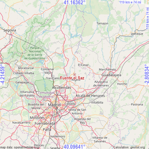
Fuente el Saz GPS coordinates[2]
40° 37' 55.74" North, 3° 30' 41.256" West
| Map corner | latitude | longitude |
|---|---|---|
| Upper-left | 41.16362°, | -4.21459° |
| Center: | 40.63215°, | -3.51146° |
| Lower-right: | 40.09641°, | -2.80834° |
| Map W x H: | 118.7×118.7 km | = 73.8×73.8mi |
| max Lat: | 43.74134° ⇑59.2% North |
| Fuente el Saz: | 40.63215° |
| min Lat: | ⇓40.8% South 27.64134° |
| min Long | Fuente el Saz | max Long |
| -18.00367° | -3.51146° | 4.2899° |
| W 47.6%⇐ | ⇒52.4% E |
Elevation
Elevation of Fuente el Saz is 642 m = 2106 ft, and this is 44 m = 144 ft above average elevation for this country.
| Max E: |
1682 m = 5518 ft | 51.6% |
| Fuente el Saz | 642 m 2106 ft | |
| Avg. | 598 m = 1962 ft | |
Min E: |
0 m = 0 ft | 48.4% |
See also: Spain elevation on elevation.city.
Geographical zone
Fuente el Saz is located in North temperate zone (between Tropic of Cancer and the Arctic Circle). Distance of this Northern Tropic circle is 1912 km =1188.1 mi to South.| Distance of | km | miles | from Fuente el Saz |
|---|---|---|---|
| North Pole | 5489.2 | 3410.8 | to North |
| Arctic Circle | 2883.3 | 1791.6 | to North |
| Tropic Cancer | 1912 | 1188.1 | to South |
| Equator | 4517.9 | 2807.3 | to South |


Nearby cities:
15 places around Fuente el Saz: (largest is in red/bold)
• Ajalvir
11.5 km =7.1 mi,  165°
165°
• Alcobendas
14.5 km =9 mi,  229°
229°
• Algete
4.1 km =2.5 mi,  163°
163°
• Cobeña
7.3 km =4.5 mi, 172°
• Daganzo de Arriba
11 km =6.8 mi,  154°
154°
• El Molar
12.5 km =7.8 mi,  332°
332°
• Fresno de Torote
9.7 km =6 mi,  118°
118°
• Paracuellos de Jarama
14.4 km =8.9 mi,  185°
185°
• Pedrezuela
14.4 km =8.9 mi, 328°
• Ribatejada
10.9 km =6.8 mi,  70°
70°
• San Agustín del Guadalix
10.3 km =6.4 mi,  300°
300°
• San Sebastián de los Reyes
13 km =8.1 mi, 228°
• Talamanca de Jarama
12.4 km =7.7 mi,  1°
1°
• Valdeolmos
5.2 km =3.2 mi,  83°
83°
• Valdetorres de Jarama
6.8 km =4.2 mi,  359°
359°
Sources, notices
• [Note1] Compared only with cities in Spain existing in our database
• [Src1] Map data: © OpenStreetMap contributors (CC-BY-SA)
• [Src2] Other city data from geonames.org with taken over terms of usage.
• [Src3] Geographical zone / Annual Mean Temperature by Robert A. Rohde @ Wikipedia
