Almazul geodata
Almazul (Castille and León) is a seat of a third-order administrative division; located in Spain in Europe/Madrid (GMT+2) time zone. With population of 137 people, there are 5525 cities with bigger population in this country. Compared to other cities in Spain, 62.7% of cities are located further ↓South; 65.5% of cities are located further ←West and 87.4% of cities have lower elevation than Almazul. Note1


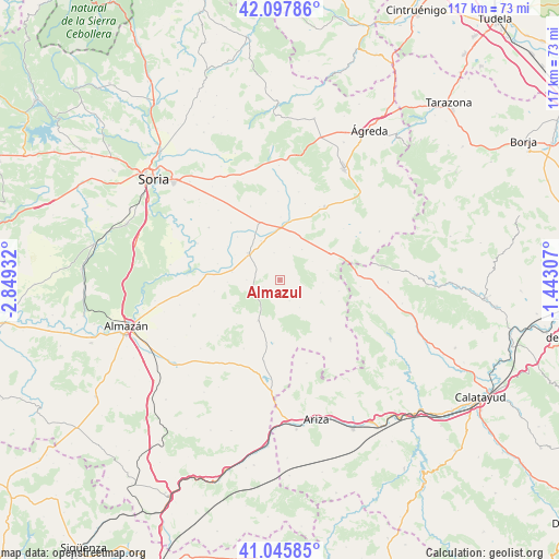
Almazul GPS coordinates[2]
41° 34' 26.4" North, 2° 8' 46.32" West
| Map corner | latitude | longitude |
|---|---|---|
| Upper-left | 42.09786°, | -2.84932° |
| Center: | 41.574°, | -2.1462° |
| Lower-right: | 41.04585°, | -1.44307° |
| Map W x H: | 117×117 km | = 72.7×72.7mi |
| max Lat: | 43.74134° ⇑37.3% North |
| Almazul: | 41.574° |
| min Lat: | ⇓62.7% South 27.64134° |
| min Long | Almazul | max Long |
| -18.00367° | -2.1462° | 4.2899° |
| W 65.5%⇐ | ⇒34.5% E |
Elevation
Elevation of Almazul is 987 m = 3238 ft, and this is 389 m = 1276 ft above average elevation for this country.
| Max E: |
1682 m = 5518 ft | 12.6% |
| Almazul | 987 m 3238 ft | |
| Avg. | 598 m = 1962 ft | |
Min E: |
0 m = 0 ft | 87.4% |
See also: Spain elevation on elevation.city.
Geographical zone
Almazul is located in North temperate zone (between Tropic of Cancer and the Arctic Circle). Distance of this Northern Tropic circle is 2016.7 km =1253.1 mi to South.| Distance of | km | miles | from Almazul |
|---|---|---|---|
| North Pole | 5384.5 | 3345.8 | to North |
| Arctic Circle | 2778.6 | 1726.5 | to North |
| Tropic Cancer | 2016.7 | 1253.1 | to South |
| Equator | 4622.6 | 2872.3 | to South |


Nearby cities:
15 places around Almazul: (largest is in red/bold)
• Aliud
12.6 km =7.8 mi,  315°
315°
• Almenar de Soria
12.9 km =8 mi,  339°
339°
• Bliecos
11.6 km =7.2 mi,  243°
243°
• Buberos
9 km =5.6 mi,  333°
333°
• Cabrejas del Campo
15.7 km =9.8 mi, 319°
• Carabantes
12.6 km =7.8 mi,  101°
101°
• Ciria
15.8 km =9.8 mi,  71°
71°
• Gómara
8.6 km =5.3 mi,  310°
310°
• Portillo de Soria
7.1 km =4.4 mi,  16°
16°
• Reznos
10 km =6.2 mi,  79°
79°
• Tejado
10.2 km =6.3 mi,  279°
279°
• Torlengua
13.3 km =8.3 mi,  185°
185°
• Torrubia de Soria
7.8 km =4.8 mi,  35°
35°
• Velilla de los Ajos
13 km =8.1 mi,  224°
224°
• Villaseca de Arciel
5.7 km =3.5 mi,  346°
346°
Sources, notices
• [Note1] Compared only with cities in Spain existing in our database
• [Src1] Map data: © OpenStreetMap contributors (CC-BY-SA)
• [Src2] Other city data from geonames.org with taken over terms of usage.
• [Src3] Geographical zone / Annual Mean Temperature by Robert A. Rohde @ Wikipedia
