Corcubión geodata
Corcubión (Galicia) is a seat of a third-order administrative division; located in Spain in Europe/Madrid (GMT+2) time zone. With population of 1,941 people, there are 2210 cities with bigger population in this country. Compared to other cities in Spain, 94% of cities are located further ↓South; 98.3% of cities are located further →East and 97.3% of cities have higher elevation than Corcubión. Note1


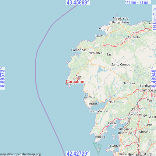
Corcubión GPS coordinates[2]
42° 56' 38.904" North, 9° 11' 33.36" West
| Map corner | latitude | longitude |
|---|---|---|
| Upper-left | 43.45669°, | -9.89573° |
| Center: | 42.94414°, | -9.1926° |
| Lower-right: | 42.42729°, | -8.48948° |
| Map W x H: | 114.5×114.5 km | = 71.1×71.1mi |
| max Lat: | 43.74134° ⇑6% North |
| Corcubión: | 42.94414° |
| min Lat: | ⇓94% South 27.64134° |
| min Long | Corcubión | max Long |
| -18.00367° | -9.1926° | 4.2899° |
| W 1.7%⇐ | ⇒98.3% E |
Elevation
Elevation of Corcubión is 14 m = 46 ft, and this is 584 m = 1916 ft below average elevation for this country.
| Max E: |
1682 m = 5518 ft | 97.3% |
| Avg. | 598 m = 1962 ft | |
| Corcubión | 14 m = 46 ft | |
Min E: |
0 m = 0 ft | 2.7% |
See also: Spain elevation on elevation.city.
Geographical zone
Corcubión is located in North temperate zone (between Tropic of Cancer and the Arctic Circle). Distance of this Northern Tropic circle is 2169 km =1347.8 mi to South.| Distance of | km | miles | from Corcubión |
|---|---|---|---|
| North Pole | 5232.1 | 3251.1 | to North |
| Arctic Circle | 2626.2 | 1631.8 | to North |
| Tropic Cancer | 2169 | 1347.8 | to South |
| Equator | 4774.9 | 2967 | to South |


Nearby cities:
15 places around Corcubión: (largest is in red/bold)
• Camariñas
20.8 km =12.9 mi,  2°
2°
• Carnota
15.9 km =9.9 mi,  147°
147°
• Cee
1.2 km =0.7 mi,  17°
17°
• Dumbría
9.6 km =6 mi,  42°
42°
• Fisterra
7.2 km =4.5 mi,  232°
232°
• Mazaricos
18 km =11.2 mi,  91°
91°
• Mugia
17.9 km =11.1 mi,  353°
353°
• Muros
21.6 km =13.4 mi, 150°
• Noia
30.5 km =19 mi,  125°
125°
• Outes
25.4 km =15.8 mi,  111°
111°
• Porto do Son
28.8 km =17.9 mi, 147°
• Portosin
28.7 km =17.8 mi,  136°
136°
• Santa Comba
32.7 km =20.3 mi,  72°
72°
• Vimianzo
22.5 km =14 mi, 35°
• Zas
28.3 km =17.6 mi,  52°
52°
Sources, notices
• [Note1] Compared only with cities in Spain existing in our database
• [Src1] Map data: © OpenStreetMap contributors (CC-BY-SA)
• [Src2] Other city data from geonames.org with taken over terms of usage.
• [Src3] Geographical zone / Annual Mean Temperature by Robert A. Rohde @ Wikipedia
