Mazaricos geodata
Mazaricos (Galicia) is a seat of a third-order administrative division; located in Spain in Europe/Madrid (GMT+2) time zone. With population of 5,523 people, there are 1209 cities with bigger population in this country. Compared to other cities in Spain, 94% of cities are located further ↓South; 98.2% of cities are located further →East and 71.2% of cities have higher elevation than Mazaricos. Note1


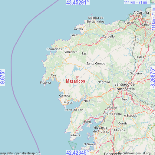
Mazaricos GPS coordinates[2]
42° 56' 25.188" North, 8° 58' 18.732" West
| Map corner | latitude | longitude |
|---|---|---|
| Upper-left | 43.45291°, | -9.675° |
| Center: | 42.94033°, | -8.97187° |
| Lower-right: | 42.42345°, | -8.26875° |
| Map W x H: | 114.5×114.5 km | = 71.1×71.1mi |
| max Lat: | 43.74134° ⇑6% North |
| Mazaricos: | 42.94033° |
| min Lat: | ⇓94% South 27.64134° |
| min Long | Mazaricos | max Long |
| -18.00367° | -8.97187° | 4.2899° |
| W 1.8%⇐ | ⇒98.2% E |
Elevation
Elevation of Mazaricos is 363 m = 1191 ft, and this is 235 m = 771 ft below average elevation for this country.
| Max E: |
1682 m = 5518 ft | 71.2% |
| Avg. | 598 m = 1962 ft | |
| Mazaricos | 363 m = 1191 ft | |
Min E: |
0 m = 0 ft | 28.8% |
See also: Spain elevation on elevation.city.
Geographical zone
Mazaricos is located in North temperate zone (between Tropic of Cancer and the Arctic Circle). Distance of this Northern Tropic circle is 2168.6 km =1347.5 mi to South.| Distance of | km | miles | from Mazaricos |
|---|---|---|---|
| North Pole | 5232.5 | 3251.3 | to North |
| Arctic Circle | 2626.7 | 1632.2 | to North |
| Tropic Cancer | 2168.6 | 1347.5 | to South |
| Equator | 4774.5 | 2966.7 | to South |


Nearby cities:
15 places around Mazaricos: (largest is in red/bold)
• A Baña
17.6 km =10.9 mi,  82°
82°
• Carnota
16.1 km =10 mi,  216°
216°
• Cee
17.7 km =11 mi,  275°
275°
• Corcubión
18 km =11.2 mi,  271°
271°
• Dumbría
13.8 km =8.6 mi,  303°
303°
• Fisterra
24 km =14.9 mi,  260°
260°
• Lousame
21.9 km =13.6 mi,  152°
152°
• Muros
19.6 km =12.2 mi,  201°
201°
• Negreira
19.1 km =11.9 mi,  102°
102°
• Noia
18.5 km =11.5 mi,  158°
158°
• Outes
10.4 km =6.5 mi, 146°
• Portosin
20.4 km =12.7 mi,  174°
174°
• Santa Comba
16.8 km =10.4 mi,  52°
52°
• Vimianzo
19.5 km =12.1 mi,  345°
345°
• Zas
18.2 km =11.3 mi,  14°
14°
Sources, notices
• [Note1] Compared only with cities in Spain existing in our database
• [Src1] Map data: © OpenStreetMap contributors (CC-BY-SA)
• [Src2] Other city data from geonames.org with taken over terms of usage.
• [Src3] Geographical zone / Annual Mean Temperature by Robert A. Rohde @ Wikipedia
