Carnota geodata
Carnota (Galicia) is a seat of a third-order administrative division; located in Spain in Europe/Madrid (GMT+2) time zone. With population of 5,171 people, there are 1270 cities with bigger population in this country. Compared to other cities in Spain, 92.9% of cities are located further ↓South; 98.3% of cities are located further →East and 96.4% of cities have higher elevation than Carnota. Note1


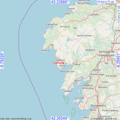
Carnota GPS coordinates[2]
42° 49' 23.88" North, 9° 5' 20.868" West
| Map corner | latitude | longitude |
|---|---|---|
| Upper-left | 43.33686°, | -9.79226° |
| Center: | 42.8233°, | -9.08913° |
| Lower-right: | 42.30544°, | -8.38601° |
| Map W x H: | 114.7×114.7 km | = 71.3×71.3mi |
| max Lat: | 43.74134° ⇑7.1% North |
| Carnota: | 42.8233° |
| min Lat: | ⇓92.9% South 27.64134° |
| min Long | Carnota | max Long |
| -18.00367° | -9.08913° | 4.2899° |
| W 1.7%⇐ | ⇒98.3% E |
Elevation
Elevation of Carnota is 18 m = 59 ft, and this is 580 m = 1903 ft below average elevation for this country.
| Max E: |
1682 m = 5518 ft | 96.4% |
| Avg. | 598 m = 1962 ft | |
| Carnota | 18 m = 59 ft | |
Min E: |
0 m = 0 ft | 3.6% |
See also: Spain elevation on elevation.city.
Geographical zone
Carnota is located in North temperate zone (between Tropic of Cancer and the Arctic Circle). Distance of this Northern Tropic circle is 2155.6 km =1339.4 mi to South.| Distance of | km | miles | from Carnota |
|---|---|---|---|
| North Pole | 5245.6 | 3259.5 | to North |
| Arctic Circle | 2639.7 | 1640.2 | to North |
| Tropic Cancer | 2155.6 | 1339.4 | to South |
| Equator | 4761.5 | 2958.7 | to South |


Nearby cities:
15 places around Carnota: (largest is in red/bold)
• A Pobra do Caramiñal
27.4 km =17 mi,  153°
153°
• Boiro
25.7 km =16 mi,  139°
139°
• Cee
16.7 km =10.4 mi,  331°
331°
• Corcubión
15.9 km =9.9 mi, 327°
• Dumbría
20.7 km =12.9 mi,  354°
354°
• Fisterra
16.8 km =10.4 mi,  302°
302°
• Lousame
20.6 km =12.8 mi,  108°
108°
• Mazaricos
16.1 km =10 mi,  36°
36°
• Muros
5.7 km =3.5 mi,  155°
155°
• Noia
17 km =10.6 mi,  104°
104°
• Oleiros
25.9 km =16.1 mi, 163°
• Outes
15.9 km =9.9 mi,  74°
74°
• Palmeira
29 km =18 mi, 156°
• Porto do Son
12.9 km =8 mi, 147°
• Portosin
13.5 km =8.4 mi,  122°
122°
Sources, notices
• [Note1] Compared only with cities in Spain existing in our database
• [Src1] Map data: © OpenStreetMap contributors (CC-BY-SA)
• [Src2] Other city data from geonames.org with taken over terms of usage.
• [Src3] Geographical zone / Annual Mean Temperature by Robert A. Rohde @ Wikipedia
