Camariñas geodata
Camariñas (Galicia) is a seat of a third-order administrative division; located in Spain in Europe/Madrid (GMT+2) time zone. With population of 6,440 people, there are 1090 cities with bigger population in this country. Compared to other cities in Spain, 95.6% of cities are located further ↓South; 98.3% of cities are located further →East and 97% of cities have higher elevation than Camariñas. Note1


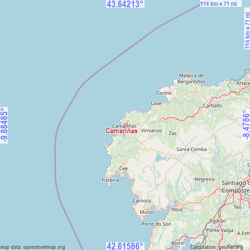
Camariñas GPS coordinates[2]
43° 7' 52.14" North, 9° 10' 54.192" West
| Map corner | latitude | longitude |
|---|---|---|
| Upper-left | 43.64213°, | -9.88485° |
| Center: | 43.13115°, | -9.18172° |
| Lower-right: | 42.61586°, | -8.4786° |
| Map W x H: | 114.1×114.1 km | = 70.9×70.9mi |
| max Lat: | 43.74134° ⇑4.4% North |
| Camariñas: | 43.13115° |
| min Lat: | ⇓95.6% South 27.64134° |
| min Long | Camariñas | max Long |
| -18.00367° | -9.18172° | 4.2899° |
| W 1.7%⇐ | ⇒98.3% E |
Elevation
Elevation of Camariñas is 15 m = 49 ft, and this is 583 m = 1913 ft below average elevation for this country.
| Max E: |
1682 m = 5518 ft | 97% |
| Avg. | 598 m = 1962 ft | |
| Camariñas | 15 m = 49 ft | |
Min E: |
0 m = 0 ft | 3% |
See also: Spain elevation on elevation.city.
Geographical zone
Camariñas is located in North temperate zone (between Tropic of Cancer and the Arctic Circle). Distance of this Northern Tropic circle is 2189.8 km =1360.7 mi to South.| Distance of | km | miles | from Camariñas |
|---|---|---|---|
| North Pole | 5211.3 | 3238.2 | to North |
| Arctic Circle | 2605.4 | 1618.9 | to North |
| Tropic Cancer | 2189.8 | 1360.7 | to South |
| Equator | 4795.7 | 2979.9 | to South |


Nearby cities:
15 places around Camariñas: (largest is in red/bold)
• Carnota
35 km =21.7 mi,  167°
167°
• Cee
19.6 km =12.2 mi,  181°
181°
• Corcubión
20.8 km =12.9 mi, 182°
• Coristanco
35.8 km =22.2 mi,  77°
77°
• Dumbría
14.7 km =9.1 mi,  157°
157°
• Fisterra
26 km =16.2 mi,  194°
194°
• Laxe
17.3 km =10.7 mi,  55°
55°
• Malpica
36.9 km =22.9 mi,  54°
54°
• Mazaricos
27.2 km =16.9 mi,  141°
141°
• Mugia
4.2 km =2.6 mi,  224°
224°
• Outes
37.6 km =23.4 mi, 142°
• San Roque
35.8 km =22.2 mi, 77°
• Santa Comba
32.2 km =20 mi,  109°
109°
• Vimianzo
12.3 km =7.6 mi,  101°
101°
• Zas
21.9 km =13.6 mi, 99°
Sources, notices
• [Note1] Compared only with cities in Spain existing in our database
• [Src1] Map data: © OpenStreetMap contributors (CC-BY-SA)
• [Src2] Other city data from geonames.org with taken over terms of usage.
• [Src3] Geographical zone / Annual Mean Temperature by Robert A. Rohde @ Wikipedia
