Vimianzo geodata
Vimianzo (Galicia) is a seat of a third-order administrative division; located in Spain in Europe/Madrid (GMT+2) time zone. In our database, there are 6762 cities with bigger population. Compared to other cities in Spain, 95.4% of cities are located further ↓South; 98.3% of cities are located further →East and 85.1% of cities have higher elevation than Vimianzo. Note1


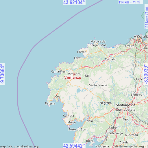
Vimianzo GPS coordinates[2]
43° 6' 35.568" North, 9° 2' 0.636" West
| Map corner | latitude | longitude |
|---|---|---|
| Upper-left | 43.62104°, | -9.73664° |
| Center: | 43.10988°, | -9.03351° |
| Lower-right: | 42.59442°, | -8.33039° |
| Map W x H: | 114.1×114.1 km | = 70.9×70.9mi |
| max Lat: | 43.74134° ⇑4.6% North |
| Vimianzo: | 43.10988° |
| min Lat: | ⇓95.4% South 27.64134° |
| min Long | Vimianzo | max Long |
| -18.00367° | -9.03351° | 4.2899° |
| W 1.7%⇐ | ⇒98.3% E |
Elevation
Elevation of Vimianzo is 136 m = 446 ft, and this is 462 m = 1516 ft below average elevation for this country.
| Max E: |
1682 m = 5518 ft | 85.1% |
| Avg. | 598 m = 1962 ft | |
| Vimianzo | 136 m = 446 ft | |
Min E: |
0 m = 0 ft | 14.9% |
See also: Spain elevation on elevation.city.
Geographical zone
Vimianzo is located in North temperate zone (between Tropic of Cancer and the Arctic Circle). Distance of this Northern Tropic circle is 2187.5 km =1359.2 mi to South.| Distance of | km | miles | from Vimianzo |
|---|---|---|---|
| North Pole | 5213.7 | 3239.6 | to North |
| Arctic Circle | 2607.8 | 1620.4 | to North |
| Tropic Cancer | 2187.5 | 1359.2 | to South |
| Equator | 4793.4 | 2978.5 | to South |


Nearby cities:
15 places around Vimianzo: (largest is in red/bold)
• A Baña
27.8 km =17.3 mi,  126°
126°
• Camariñas
12.3 km =7.6 mi,  281°
281°
• Cee
21.3 km =13.2 mi,  216°
216°
• Corcubión
22.5 km =14 mi, 215°
• Coristanco
25.1 km =15.6 mi,  66°
66°
• Dumbría
13 km =8.1 mi,  209°
209°
• Fisterra
29.4 km =18.3 mi, 219°
• Laxe
12.5 km =7.8 mi,  10°
10°
• Malpica
29.8 km =18.5 mi,  37°
37°
• Mazaricos
19.5 km =12.1 mi,  165°
165°
• Mugia
15 km =9.3 mi,  267°
267°
• Outes
29.6 km =18.4 mi,  158°
158°
• San Roque
25.1 km =15.6 mi, 66°
• Santa Comba
20.1 km =12.5 mi,  115°
115°
• Zas
9.7 km =6 mi,  97°
97°
Sources, notices
• [Note1] Compared only with cities in Spain existing in our database
• [Src1] Map data: © OpenStreetMap contributors (CC-BY-SA)
• [Src2] Other city data from geonames.org with taken over terms of usage.
• [Src3] Geographical zone / Annual Mean Temperature by Robert A. Rohde @ Wikipedia
