Santa Comba geodata
Santa Comba (Galicia) is a seat of a third-order administrative division; located in Spain in Europe/Madrid (GMT+2) time zone. With population of 10,487 people, there are 826 cities with bigger population in this country. Compared to other cities in Spain, 94.6% of cities are located further ↓South; 97.9% of cities are located further →East and 69.8% of cities have higher elevation than Santa Comba. Note1


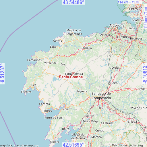
Santa Comba GPS coordinates[2]
43° 1' 59.016" North, 8° 48' 33.3" West
| Map corner | latitude | longitude |
|---|---|---|
| Upper-left | 43.54486°, | -9.51237° |
| Center: | 43.03306°, | -8.80925° |
| Lower-right: | 42.51695°, | -8.10612° |
| Map W x H: | 114.3×114.3 km | = 71×71mi |
| max Lat: | 43.74134° ⇑5.4% North |
| Santa Comba: | 43.03306° |
| min Lat: | ⇓94.6% South 27.64134° |
| min Long | Santa Comba | max Long |
| -18.00367° | -8.80925° | 4.2899° |
| W 2.1%⇐ | ⇒97.9% E |
Elevation
Elevation of Santa Comba is 384 m = 1260 ft, and this is 214 m = 702 ft below average elevation for this country.
| Max E: |
1682 m = 5518 ft | 69.8% |
| Avg. | 598 m = 1962 ft | |
| Santa Comba | 384 m = 1260 ft | |
Min E: |
0 m = 0 ft | 30.2% |
See also: Spain elevation on elevation.city.
Geographical zone
Santa Comba is located in North temperate zone (between Tropic of Cancer and the Arctic Circle). Distance of this Northern Tropic circle is 2178.9 km =1353.9 mi to South.| Distance of | km | miles | from Santa Comba |
|---|---|---|---|
| North Pole | 5222.2 | 3244.9 | to North |
| Arctic Circle | 2616.3 | 1625.7 | to North |
| Tropic Cancer | 2178.9 | 1353.9 | to South |
| Equator | 4784.8 | 2973.1 | to South |


Nearby cities:
15 places around Santa Comba: (largest is in red/bold)
• A Baña
9 km =5.6 mi,  152°
152°
• Amés
19 km =11.8 mi,  138°
138°
• Carballo
22.2 km =13.8 mi,  25°
25°
• Coristanco
19.2 km =11.9 mi,  14°
14°
• Dumbría
24.9 km =15.5 mi,  263°
263°
• Laxe
26.2 km =16.3 mi,  322°
322°
• Mazaricos
16.8 km =10.4 mi,  232°
232°
• Negreira
15.3 km =9.5 mi,  159°
159°
• Noia
28.2 km =17.5 mi,  193°
193°
• Outes
20.5 km =12.7 mi,  201°
201°
• San Roque
19.2 km =11.9 mi, 14°
• Santiago de Compostela
27.3 km =17 mi,  128°
128°
• Trazo
22.5 km =14 mi,  94°
94°
• Vimianzo
20.1 km =12.5 mi,  295°
295°
• Zas
11.3 km =7 mi,  310°
310°
Sources, notices
• [Note1] Compared only with cities in Spain existing in our database
• [Src1] Map data: © OpenStreetMap contributors (CC-BY-SA)
• [Src2] Other city data from geonames.org with taken over terms of usage.
• [Src3] Geographical zone / Annual Mean Temperature by Robert A. Rohde @ Wikipedia
