Tres Cantos geodata
Tres Cantos (Madrid) is a seat of a third-order administrative division; located in Spain in Europe/Madrid (GMT+2) time zone. With population of 41,896 people, there are 210 cities with bigger population in this country. Compared to other cities in Spain, 59.8% of cities are located further ↑North; 55.6% of cities are located further →East and 58.3% of cities have lower elevation than Tres Cantos. Note1


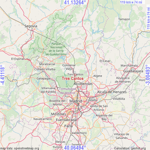
Tres Cantos GPS coordinates[2]
40° 36' 3.312" North, 3° 42' 29.016" West
| Map corner | latitude | longitude |
|---|---|---|
| Upper-left | 41.13264°, | -4.41118° |
| Center: | 40.60092°, | -3.70806° |
| Lower-right: | 40.06494°, | -3.00493° |
| Map W x H: | 118.7×118.7 km | = 73.8×73.8mi |
| max Lat: | 43.74134° ⇑59.8% North |
| Tres Cantos: | 40.60092° |
| min Lat: | ⇓40.2% South 27.64134° |
| min Long | Tres Cantos | max Long |
| -18.00367° | -3.70806° | 4.2899° |
| W 44.4%⇐ | ⇒55.6% E |
Elevation
Elevation of Tres Cantos is 731 m = 2398 ft, and this is 133 m = 436 ft above average elevation for this country.
| Max E: |
1682 m = 5518 ft | 41.7% |
| Tres Cantos | 731 m 2398 ft | |
| Avg. | 598 m = 1962 ft | |
Min E: |
0 m = 0 ft | 58.3% |
See also: Tres Cantos elevation on elevation.city.
Geographical zone
Tres Cantos is located in North temperate zone (between Tropic of Cancer and the Arctic Circle). Distance of this Northern Tropic circle is 1908.5 km =1185.9 mi to South.| Distance of | km | miles | from Tres Cantos |
|---|---|---|---|
| North Pole | 5492.7 | 3413 | to North |
| Arctic Circle | 2886.8 | 1793.8 | to North |
| Tropic Cancer | 1908.5 | 1185.9 | to South |
| Equator | 4514.4 | 2805.1 | to South |


Nearby cities:
15 places around Tres Cantos: (largest is in red/bold)
• Alcobendas
8.2 km =5.1 mi,  136°
136°
• Algete
17.8 km =11.1 mi,  91°
91°
• Chamartín
15.7 km =9.8 mi,  170°
170°
• Colmenar Viejo
8.2 km =5.1 mi,  322°
322°
• El Pardo
11 km =6.8 mi,  209°
209°
• Fuencarral-El Pardo
11.6 km =7.2 mi,  189°
189°
• Fuente el Saz
17 km =10.6 mi,  78°
78°
• Hortaleza
15.2 km =9.4 mi,  158°
158°
• Hoyo de Manzanares
17 km =10.6 mi,  278°
278°
• Las Matas
16.2 km =10.1 mi,  252°
252°
• Las Tablas
10.9 km =6.8 mi, 163°
• Pinar de Chamartín
14 km =8.7 mi, 166°
• San Agustín del Guadalix
11.6 km =7.2 mi,  41°
41°
• San Sebastián de los Reyes
8.5 km =5.3 mi,  126°
126°
• Tetuán de las Victorias
15.7 km =9.8 mi,  176°
176°
Sources, notices
• [Note1] Compared only with cities in Spain existing in our database
• [Src1] Map data: © OpenStreetMap contributors (CC-BY-SA)
• [Src2] Other city data from geonames.org with taken over terms of usage.
• [Src3] Geographical zone / Annual Mean Temperature by Robert A. Rohde @ Wikipedia
