Cobeta geodata
Cobeta (Castille-La Mancha) is a seat of a third-order administrative division; located in Spain in Europe/Madrid (GMT+2) time zone. With population of 111 people, there are 5802 cities with bigger population in this country. Compared to other cities in Spain, 54.6% of cities are located further ↑North; 65.6% of cities are located further ←West and 94.3% of cities have lower elevation than Cobeta. Note1
Administrative division(s):
- Level 1: Castille-La Mancha
- Level 2: Provincia de Guadalajara
- Level 3: Cobeta


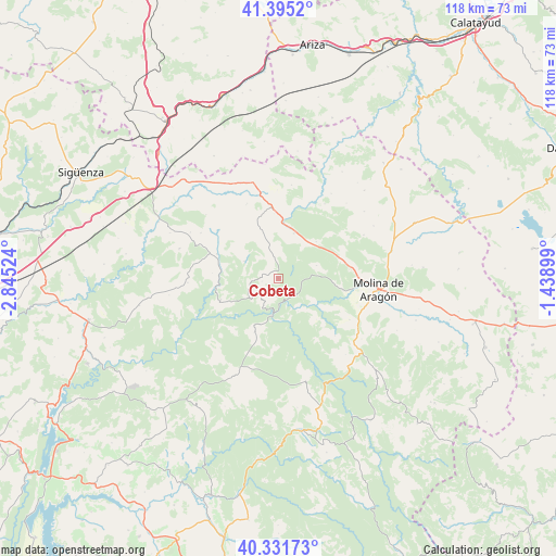
Cobeta GPS coordinates[2]
40° 51' 56.16" North, 2° 8' 31.596" West
| Map corner | latitude | longitude |
|---|---|---|
| Upper-left | 41.3952°, | -2.84524° |
| Center: | 40.8656°, | -2.14211° |
| Lower-right: | 40.33173°, | -1.43899° |
| Map W x H: | 118.2×118.2 km | = 73.4×73.4mi |
| max Lat: | 43.74134° ⇑54.6% North |
| Cobeta: | 40.8656° |
| min Lat: | ⇓45.4% South 27.64134° |
| min Long | Cobeta | max Long |
| -18.00367° | -2.14211° | 4.2899° |
| W 65.6%⇐ | ⇒34.4% E |
Elevation
Elevation of Cobeta is 1123 m = 3684 ft, and this is 525 m = 1722 ft above average elevation for this country.
| Max E: |
1682 m = 5518 ft | 5.7% |
| Cobeta | 1123 m 3684 ft | |
| Avg. | 598 m = 1962 ft | |
Min E: |
0 m = 0 ft | 94.3% |
See also: Spain elevation on elevation.city.
Geographical zone
Cobeta is located in North temperate zone (between Tropic of Cancer and the Arctic Circle). Distance of this Northern Tropic circle is 1937.9 km =1204.2 mi to South.| Distance of | km | miles | from Cobeta |
|---|---|---|---|
| North Pole | 5463.2 | 3394.7 | to North |
| Arctic Circle | 2857.3 | 1775.4 | to North |
| Tropic Cancer | 1937.9 | 1204.2 | to South |
| Equator | 4543.8 | 2823.4 | to South |


Nearby cities:
15 places around Cobeta: (largest is in red/bold)
• Ablanque
7.9 km =4.9 mi,  297°
297°
• Anquela del Ducado
11.7 km =7.3 mi,  4°
4°
• Corduente
14 km =8.7 mi,  100°
100°
• Fuembellida
17.2 km =10.7 mi,  135°
135°
• Herrería
15.5 km =9.6 mi,  80°
80°
• Huertahernando
13.1 km =8.1 mi,  248°
248°
• Mazarete
15.1 km =9.4 mi,  354°
354°
• Olmeda de Cobeta
3.5 km =2.2 mi,  259°
259°
• Riba de Saelices
14 km =8.7 mi,  291°
291°
• Rillo de Gallo
17.2 km =10.7 mi,  89°
89°
• Saelices de la Sal
15.9 km =9.9 mi, 286°
• Selas
10.1 km =6.3 mi,  19°
19°
• Torremocha del Pinar
8.6 km =5.3 mi,  71°
71°
• Valhermoso
17.6 km =10.9 mi,  120°
120°
• Zaorejas
12.5 km =7.8 mi,  203°
203°
Sources, notices
• [Note1] Compared only with cities in Spain existing in our database
• [Src1] Map data: © OpenStreetMap contributors (CC-BY-SA)
• [Src2] Other city data from geonames.org with taken over terms of usage.
• [Src3] Geographical zone / Annual Mean Temperature by Robert A. Rohde @ Wikipedia
