Albocàsser geodata
Albocàsser (Valencia) is a populated place; located in Spain in Europe/Madrid (GMT+2) time zone. With population of 1,391 people, there are 2554 cities with bigger population in this country. Compared to other cities in Spain, 64.9% of cities are located further ↑North; 87.2% of cities are located further ←West and 57.1% of cities have higher elevation than Albocàsser. Note1
Administrative division(s):
- Level 1: Valencia
- Level 2: Província de Castelló
- Level 3: Coves de Vinromà, les


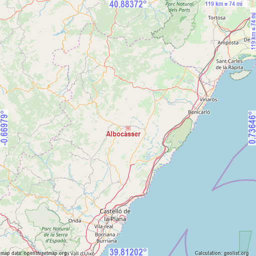
Albocàsser GPS coordinates[2]
40° 21' 0" North, 0° 1' 59.988" East
| Map corner | latitude | longitude |
|---|---|---|
| Upper-left | 40.88372°, | -0.66979° |
| Center: | 40.35°, | 0.03333° |
| Lower-right: | 39.81202°, | 0.73646° |
| Map W x H: | 119.2×119.2 km | = 74.1×74.1mi |
| max Lat: | 43.74134° ⇑64.9% North |
| Albocàsser: | 40.35° |
| min Lat: | ⇓35.1% South 27.64134° |
| min Long | Albocàsser | max Long |
| -18.00367° | 0.03333° | 4.2899° |
| W 87.2%⇐ | ⇒12.8% E |
Elevation
Elevation of Albocàsser is 564 m = 1850 ft, and this is 34 m = 112 ft below average elevation for this country.
| Max E: |
1682 m = 5518 ft | 57.1% |
| Avg. | 598 m = 1962 ft | |
| Albocàsser | 564 m = 1850 ft | |
Min E: |
0 m = 0 ft | 42.9% |
See also: Spain elevation on elevation.city.
Geographical zone
Albocàsser is located in North temperate zone (between Tropic of Cancer and the Arctic Circle). Distance of this Northern Tropic circle is 1880.6 km =1168.6 mi to South.| Distance of | km | miles | from Albocàsser |
|---|---|---|---|
| North Pole | 5520.6 | 3430.3 | to North |
| Arctic Circle | 2914.7 | 1811.1 | to North |
| Tropic Cancer | 1880.6 | 1168.6 | to South |
| Equator | 4486.5 | 2787.8 | to South |


Nearby cities:
15 places around Albocàsser: (largest is in red/bold)
• Alcalà de Xivert
17.8 km =11.1 mi,  108°
108°
• Ares del Maestre
18.4 km =11.4 mi,  310°
310°
• Benafigos
22 km =13.7 mi,  248°
248°
• Benassal
15 km =9.3 mi,  281°
281°
• Benlloch
15.5 km =9.6 mi,  181°
181°
• Cabanes
21.6 km =13.4 mi, 177°
• Catí
13.5 km =8.4 mi,  356°
356°
• Chert/Xert
21.6 km =13.4 mi,  29°
29°
• Cuevas de Vinromá
8.7 km =5.4 mi,  121°
121°
• Culla
16.9 km =10.5 mi,  264°
264°
• Salsadella
14.2 km =8.8 mi,  57°
57°
• Sarratella
4.1 km =2.5 mi, 182°
• Sierra-Engarcerán
10 km =6.2 mi,  206°
206°
• Tirig
9 km =5.6 mi,  24°
24°
• Torreblanca
20 km =12.4 mi,  136°
136°
Sources, notices
• [Note1] Compared only with cities in Spain existing in our database
• [Src1] Map data: © OpenStreetMap contributors (CC-BY-SA)
• [Src2] Other city data from geonames.org with taken over terms of usage.
• [Src3] Geographical zone / Annual Mean Temperature by Robert A. Rohde @ Wikipedia
