Amoeiro geodata
Amoeiro (Galicia) is a seat of a third-order administrative division; located in Spain in Europe/Madrid (GMT+2) time zone. With population of 2,354 people, there are 1968 cities with bigger population in this country. Compared to other cities in Spain, 85.3% of cities are located further ↓South; 96.2% of cities are located further →East and 68.1% of cities have higher elevation than Amoeiro. Note1


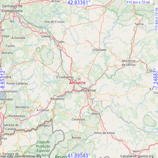
Amoeiro GPS coordinates[2]
42° 25' 0.012" North, 7° 57' 0" West
| Map corner | latitude | longitude |
|---|---|---|
| Upper-left | 42.93361°, | -8.65312° |
| Center: | 42.41667°, | -7.95° |
| Lower-right: | 41.89543°, | -7.24687° |
| Map W x H: | 115.4×115.4 km | = 71.7×71.7mi |
| max Lat: | 43.74134° ⇑14.7% North |
| Amoeiro: | 42.41667° |
| min Lat: | ⇓85.3% South 27.64134° |
| min Long | Amoeiro | max Long |
| -18.00367° | -7.95° | 4.2899° |
| W 3.8%⇐ | ⇒96.2% E |
Elevation
Elevation of Amoeiro is 415 m = 1362 ft, and this is 183 m = 600 ft below average elevation for this country.
| Max E: |
1682 m = 5518 ft | 68.1% |
| Avg. | 598 m = 1962 ft | |
| Amoeiro | 415 m = 1362 ft | |
Min E: |
0 m = 0 ft | 31.9% |
See also: Spain elevation on elevation.city.
Geographical zone
Amoeiro is located in North temperate zone (between Tropic of Cancer and the Arctic Circle). Distance of this Northern Tropic circle is 2110.4 km =1311.3 mi to South.| Distance of | km | miles | from Amoeiro |
|---|---|---|---|
| North Pole | 5290.8 | 3287.5 | to North |
| Arctic Circle | 2684.9 | 1668.3 | to North |
| Tropic Cancer | 2110.4 | 1311.3 | to South |
| Equator | 4716.3 | 2930.6 | to South |


Nearby cities:
15 places around Amoeiro: (largest is in red/bold)
• Boborás
16.1 km =10 mi,  276°
276°
• Carballedo
15.4 km =9.6 mi,  40°
40°
• Cea
7.2 km =4.5 mi,  334°
334°
• Cenlle
14.2 km =8.8 mi,  234°
234°
• Coles
9.8 km =6.1 mi,  100°
100°
• Maside
6.3 km =3.9 mi,  263°
263°
• O Carballiño
10.7 km =6.6 mi, 278°
• Ourense
11.4 km =7.1 mi,  141°
141°
• Pereiro de Aguiar
14.7 km =9.1 mi,  122°
122°
• Piñor
10.3 km =6.4 mi,  335°
335°
• Punxín
7.1 km =4.4 mi,  224°
224°
• San Amaro
11.2 km =7 mi,  244°
244°
• Toén
11 km =6.8 mi,  181°
181°
• Vilamarín
7.2 km =4.5 mi, 41°
• Vilarnaz
7.4 km =4.6 mi, 104°
Sources, notices
• [Note1] Compared only with cities in Spain existing in our database
• [Src1] Map data: © OpenStreetMap contributors (CC-BY-SA)
• [Src2] Other city data from geonames.org with taken over terms of usage.
• [Src3] Geographical zone / Annual Mean Temperature by Robert A. Rohde @ Wikipedia
