O Carballiño geodata
O Carballiño (Galicia) is a populated place; located in Spain in Europe/Madrid (GMT+2) time zone. With population of 14,114 people, there are 655 cities with bigger population in this country. Compared to other cities in Spain, 85.8% of cities are located further ↓South; 96.5% of cities are located further →East and 68.8% of cities have higher elevation than O Carballiño. Note1


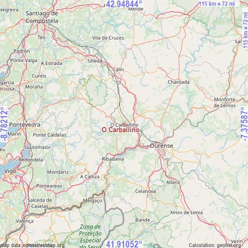
O Carballiño GPS coordinates[2]
42° 25' 53.868" North, 8° 4' 44.364" West
| Map corner | latitude | longitude |
|---|---|---|
| Upper-left | 42.94844°, | -8.78212° |
| Center: | 42.43163°, | -8.07899° |
| Lower-right: | 41.91052°, | -7.37587° |
| Map W x H: | 115.4×115.4 km | = 71.7×71.7mi |
| max Lat: | 43.74134° ⇑14.2% North |
| O Carballiño: | 42.43163° |
| min Lat: | ⇓85.8% South 27.64134° |
| min Long | O Carballiño | max Long |
| -18.00367° | -8.07899° | 4.2899° |
| W 3.5%⇐ | ⇒96.5% E |
Elevation
Elevation of O Carballiño is 402 m = 1319 ft, and this is 196 m = 643 ft below average elevation for this country.
| Max E: |
1682 m = 5518 ft | 68.8% |
| Avg. | 598 m = 1962 ft | |
| O Carballiño | 402 m = 1319 ft | |
Min E: |
0 m = 0 ft | 31.2% |
See also: Spain elevation on elevation.city.
Geographical zone
O Carballiño is located in North temperate zone (between Tropic of Cancer and the Arctic Circle). Distance of this Northern Tropic circle is 2112 km =1312.3 mi to South.| Distance of | km | miles | from O Carballiño |
|---|---|---|---|
| North Pole | 5289.1 | 3286.5 | to North |
| Arctic Circle | 2683.2 | 1667.3 | to North |
| Tropic Cancer | 2112 | 1312.3 | to South |
| Equator | 4718 | 2931.6 | to South |


Nearby cities:
15 places around O Carballiño: (largest is in red/bold)
• Amoeiro
10.7 km =6.6 mi,  98°
98°
• Avión
15 km =9.3 mi,  249°
249°
• Beade
12 km =7.5 mi,  200°
200°
• Boborás
5.4 km =3.4 mi,  272°
272°
• Carballeda de Avia
14.1 km =8.8 mi,  209°
209°
• Castrelo de Miño
14.9 km =9.3 mi,  176°
176°
• Cea
8.9 km =5.5 mi,  57°
57°
• Cenlle
10 km =6.2 mi,  185°
185°
• Maside
5 km =3.1 mi,  118°
118°
• Piñor
10 km =6.2 mi,  39°
39°
• Punxín
8.8 km =5.5 mi,  140°
140°
• Ribadavia
16.8 km =10.4 mi, 198°
• San Amaro
6.4 km =4 mi, 175°
• Toén
16.3 km =10.1 mi, 141°
• Vilamarín
15.8 km =9.8 mi,  76°
76°
Sources, notices
• [Note1] Compared only with cities in Spain existing in our database
• [Src1] Map data: © OpenStreetMap contributors (CC-BY-SA)
• [Src2] Other city data from geonames.org with taken over terms of usage.
• [Src3] Geographical zone / Annual Mean Temperature by Robert A. Rohde @ Wikipedia
