Cebreros geodata
Cebreros (Castille and León) is a seat of a third-order administrative division; located in Spain in Europe/Madrid (GMT+2) time zone. With population of 3,226 people, there are 1654 cities with bigger population in this country. Compared to other cities in Spain, 62.8% of cities are located further ↑North; 65.7% of cities are located further →East and 64.6% of cities have lower elevation than Cebreros. Note1
Administrative division(s):
- Level 1: Castille and León
- Level 2: Provincia de Ávila
- Level 3: Cebreros


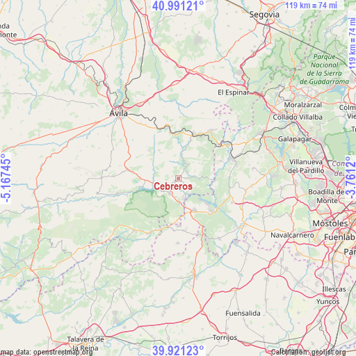
Cebreros GPS coordinates[2]
40° 27' 30.06" North, 4° 27' 51.588" West
| Map corner | latitude | longitude |
|---|---|---|
| Upper-left | 40.99121°, | -5.16745° |
| Center: | 40.45835°, | -4.46433° |
| Lower-right: | 39.92123°, | -3.7612° |
| Map W x H: | 119×119 km | = 73.9×73.9mi |
| max Lat: | 43.74134° ⇑62.8% North |
| Cebreros: | 40.45835° |
| min Lat: | ⇓37.2% South 27.64134° |
| min Long | Cebreros | max Long |
| -18.00367° | -4.46433° | 4.2899° |
| W 34.3%⇐ | ⇒65.7% E |
Elevation
Elevation of Cebreros is 775 m = 2543 ft, and this is 177 m = 581 ft above average elevation for this country.
| Max E: |
1682 m = 5518 ft | 35.4% |
| Cebreros | 775 m 2543 ft | |
| Avg. | 598 m = 1962 ft | |
Min E: |
0 m = 0 ft | 64.6% |
See also: Spain elevation on elevation.city.
Geographical zone
Cebreros is located in North temperate zone (between Tropic of Cancer and the Arctic Circle). Distance of this Northern Tropic circle is 1892.6 km =1176 mi to South.| Distance of | km | miles | from Cebreros |
|---|---|---|---|
| North Pole | 5508.5 | 3422.8 | to North |
| Arctic Circle | 2902.6 | 1803.6 | to North |
| Tropic Cancer | 1892.6 | 1176 | to South |
| Equator | 4498.5 | 2795.2 | to South |


Nearby cities:
15 places around Cebreros: (largest is in red/bold)
• Barraco
15.3 km =9.5 mi,  277°
277°
• Cadalso de los Vidrios
17.7 km =11 mi,  171°
171°
• Casillas
17.3 km =10.7 mi,  211°
211°
• El Herradón
14.3 km =8.9 mi,  325°
325°
• El Hoyo de Pinares
5.8 km =3.6 mi,  36°
36°
• El Tiemblo
5.7 km =3.5 mi, 213°
• Navahondilla
15.1 km =9.4 mi,  190°
190°
• Navalperal de Pinares
15.7 km =9.8 mi,  16°
16°
• Pelayos de la Presa
15.5 km =9.6 mi,  134°
134°
• Rozas de Puerto Real
15.8 km =9.8 mi, 185°
• San Bartolomé de Pinares
11.4 km =7.1 mi, 325°
• San Juan de la Nava
18.6 km =11.6 mi, 277°
• San Martín de Valdeiglesias
12.1 km =7.5 mi,  152°
152°
• Santa Cruz de Pinares
13.6 km =8.5 mi,  313°
313°
• Valdemaqueda
15.3 km =9.5 mi,  67°
67°
Sources, notices
• [Note1] Compared only with cities in Spain existing in our database
• [Src1] Map data: © OpenStreetMap contributors (CC-BY-SA)
• [Src2] Other city data from geonames.org with taken over terms of usage.
• [Src3] Geographical zone / Annual Mean Temperature by Robert A. Rohde @ Wikipedia
