Valdemaqueda geodata
Valdemaqueda (Madrid) is a seat of a third-order administrative division; located in Spain in Europe/Madrid (GMT+2) time zone. With population of 775 people, there are 3259 cities with bigger population in this country. Compared to other cities in Spain, 61.5% of cities are located further ↑North; 63.8% of cities are located further →East and 76.1% of cities have lower elevation than Valdemaqueda. Note1


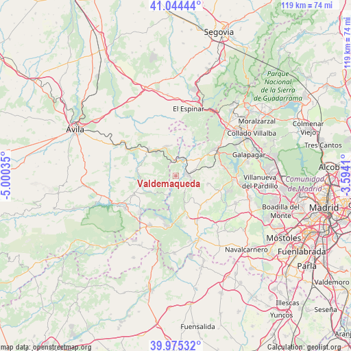
Valdemaqueda GPS coordinates[2]
40° 30' 43.236" North, 4° 17' 49.992" West
| Map corner | latitude | longitude |
|---|---|---|
| Upper-left | 41.04444°, | -5.00035° |
| Center: | 40.51201°, | -4.29722° |
| Lower-right: | 39.97532°, | -3.5941° |
| Map W x H: | 118.9×118.9 km | = 73.9×73.9mi |
| max Lat: | 43.74134° ⇑61.5% North |
| Valdemaqueda: | 40.51201° |
| min Lat: | ⇓38.5% South 27.64134° |
| min Long | Valdemaqueda | max Long |
| -18.00367° | -4.29722° | 4.2899° |
| W 36.2%⇐ | ⇒63.8% E |
Elevation
Elevation of Valdemaqueda is 861 m = 2825 ft, and this is 263 m = 863 ft above average elevation for this country.
| Max E: |
1682 m = 5518 ft | 23.9% |
| Valdemaqueda | 861 m 2825 ft | |
| Avg. | 598 m = 1962 ft | |
Min E: |
0 m = 0 ft | 76.1% |
See also: Spain elevation on elevation.city.
Geographical zone
Valdemaqueda is located in North temperate zone (between Tropic of Cancer and the Arctic Circle). Distance of this Northern Tropic circle is 1898.6 km =1179.7 mi to South.| Distance of | km | miles | from Valdemaqueda |
|---|---|---|---|
| North Pole | 5502.5 | 3419.1 | to North |
| Arctic Circle | 2896.7 | 1799.9 | to North |
| Tropic Cancer | 1898.6 | 1179.7 | to South |
| Equator | 4504.5 | 2799 | to South |


Nearby cities:
15 places around Valdemaqueda: (largest is in red/bold)
• Cebreros
15.3 km =9.5 mi,  247°
247°
• Chapinería
16.5 km =10.3 mi,  153°
153°
• Colmenar del Arroyo
13.3 km =8.3 mi,  141°
141°
• El Escorial
16.3 km =10.1 mi,  61°
61°
• El Hoyo de Pinares
10.8 km =6.7 mi,  263°
263°
• Fresnedillas
11 km =6.8 mi,  104°
104°
• Las Navas del Marqués
10.5 km =6.5 mi,  342°
342°
• Navalagamella
15.5 km =9.6 mi,  108°
108°
• Navalperal de Pinares
13.3 km =8.3 mi,  313°
313°
• Navas del Rey
14.5 km =9 mi,  164°
164°
• Peguerinos
13.9 km =8.6 mi,  23°
23°
• Robledo de Chavela
5.3 km =3.3 mi, 103°
• San Lorenzo de El Escorial
15.4 km =9.6 mi, 55°
• Santa María de la Alameda
9.8 km =6.1 mi, 19°
• Zarzalejo
10.6 km =6.6 mi,  67°
67°
Sources, notices
• [Note1] Compared only with cities in Spain existing in our database
• [Src1] Map data: © OpenStreetMap contributors (CC-BY-SA)
• [Src2] Other city data from geonames.org with taken over terms of usage.
• [Src3] Geographical zone / Annual Mean Temperature by Robert A. Rohde @ Wikipedia
