Casillas geodata
Casillas (Castille and León) is a seat of a third-order administrative division; located in Spain in Europe/Madrid (GMT+2) time zone. With population of 838 people, there are 3149 cities with bigger population in this country. Compared to other cities in Spain, 65.3% of cities are located further ↑North; 67% of cities are located further →East and 91% of cities have lower elevation than Casillas. Note1
Administrative division(s):
- Level 1: Castille and León
- Level 2: Provincia de Ávila
- Level 3: Casillas


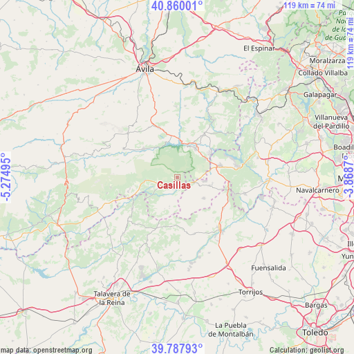
Casillas GPS coordinates[2]
40° 19' 33.96" North, 4° 34' 18.552" West
| Map corner | latitude | longitude |
|---|---|---|
| Upper-left | 40.86001°, | -5.27495° |
| Center: | 40.3261°, | -4.57182° |
| Lower-right: | 39.78793°, | -3.8687° |
| Map W x H: | 119.2×119.2 km | = 74.1×74.1mi |
| max Lat: | 43.74134° ⇑65.3% North |
| Casillas: | 40.3261° |
| min Lat: | ⇓34.7% South 27.64134° |
| min Long | Casillas | max Long |
| -18.00367° | -4.57182° | 4.2899° |
| W 33%⇐ | ⇒67% E |
Elevation
Elevation of Casillas is 1048 m = 3438 ft, and this is 450 m = 1476 ft above average elevation for this country.
| Max E: |
1682 m = 5518 ft | 9% |
| Casillas | 1048 m 3438 ft | |
| Avg. | 598 m = 1962 ft | |
Min E: |
0 m = 0 ft | 91% |
See also: Spain elevation on elevation.city.
Geographical zone
Casillas is located in North temperate zone (between Tropic of Cancer and the Arctic Circle). Distance of this Northern Tropic circle is 1877.9 km =1166.9 mi to South.| Distance of | km | miles | from Casillas |
|---|---|---|---|
| North Pole | 5523.2 | 3432 | to North |
| Arctic Circle | 2917.3 | 1812.7 | to North |
| Tropic Cancer | 1877.9 | 1166.9 | to South |
| Equator | 4483.8 | 2786.1 | to South |


Nearby cities:
15 places around Casillas: (largest is in red/bold)
• Cadalso de los Vidrios
12.1 km =7.5 mi,  103°
103°
• Casavieja
17.2 km =10.7 mi,  253°
253°
• Cebreros
17.3 km =10.7 mi,  31°
31°
• Cenicientos
11.2 km =7 mi,  127°
127°
• El Tiemblo
11.6 km =7.2 mi, 30°
• Fresnedilla
11.3 km =7 mi,  202°
202°
• Higuera de las Dueñas
10 km =6.2 mi, 195°
• La Adrada
6.2 km =3.9 mi,  241°
241°
• Navahondilla
6.4 km =4 mi,  90°
90°
• Navaluenga
15 km =9.3 mi,  309°
309°
• Pelahustán
16.8 km =10.4 mi,  187°
187°
• Piedralaves
10.9 km =6.8 mi,  264°
264°
• Rozas de Puerto Real
7.6 km =4.7 mi, 97°
• San Martín de Valdeiglesias
15.2 km =9.4 mi,  74°
74°
• Sotillo de la Adrada
4 km =2.5 mi, 194°
Sources, notices
• [Note1] Compared only with cities in Spain existing in our database
• [Src1] Map data: © OpenStreetMap contributors (CC-BY-SA)
• [Src2] Other city data from geonames.org with taken over terms of usage.
• [Src3] Geographical zone / Annual Mean Temperature by Robert A. Rohde @ Wikipedia
