Castrogeriz geodata
Castrogeriz (Castille and León) is a populated place; located in Spain in Europe/Madrid (GMT+2) time zone. With population of 935 people, there are 3032 cities with bigger population in this country. Compared to other cities in Spain, 81.5% of cities are located further ↓South; 61.8% of cities are located further →East and 70.6% of cities have lower elevation than Castrogeriz. Note1
Administrative division(s):
- Level 1: Castille and León
- Level 2: Provincia de Burgos
- Level 3: Castrojeriz


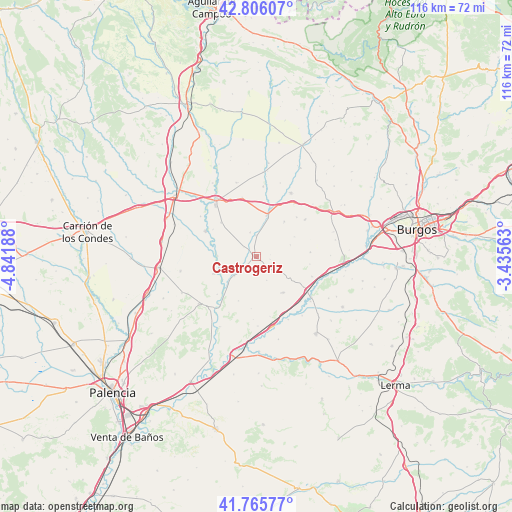
Castrogeriz GPS coordinates[2]
42° 17' 17.052" North, 4° 8' 19.536" West
| Map corner | latitude | longitude |
|---|---|---|
| Upper-left | 42.80607°, | -4.84188° |
| Center: | 42.28807°, | -4.13876° |
| Lower-right: | 41.76577°, | -3.43563° |
| Map W x H: | 115.7×115.7 km | = 71.9×71.9mi |
| max Lat: | 43.74134° ⇑18.5% North |
| Castrogeriz: | 42.28807° |
| min Lat: | ⇓81.5% South 27.64134° |
| min Long | Castrogeriz | max Long |
| -18.00367° | -4.13876° | 4.2899° |
| W 38.2%⇐ | ⇒61.8% E |
Elevation
Elevation of Castrogeriz is 818 m = 2684 ft, and this is 220 m = 722 ft above average elevation for this country.
| Max E: |
1682 m = 5518 ft | 29.4% |
| Castrogeriz | 818 m 2684 ft | |
| Avg. | 598 m = 1962 ft | |
Min E: |
0 m = 0 ft | 70.6% |
See also: Spain elevation on elevation.city.
Geographical zone
Castrogeriz is located in North temperate zone (between Tropic of Cancer and the Arctic Circle). Distance of this Northern Tropic circle is 2096.1 km =1302.5 mi to South.| Distance of | km | miles | from Castrogeriz |
|---|---|---|---|
| North Pole | 5305.1 | 3296.4 | to North |
| Arctic Circle | 2699.2 | 1677.2 | to North |
| Tropic Cancer | 2096.1 | 1302.5 | to South |
| Equator | 4702 | 2921.7 | to South |


Nearby cities:
15 places around Castrogeriz: (largest is in red/bold)
• Castellanos de Castro
9.7 km =6 mi,  62°
62°
• Hontanas
8.2 km =5.1 mi,  70°
70°
• Iglesias
12.3 km =7.6 mi,  84°
84°
• Itero de la Vega
9.7 km =6 mi,  269°
269°
• Itero del Castillo
8.7 km =5.4 mi, 271°
• Lantadilla
12.9 km =8 mi,  296°
296°
• Melgar de Yuso
10.2 km =6.3 mi,  248°
248°
• Padilla de Abajo
13.7 km =8.5 mi,  346°
346°
• Pedrosa del Príncipe
6.5 km =4 mi,  228°
228°
• Tamarón
12.2 km =7.6 mi,  97°
97°
• Villaldemiro
13.4 km =8.3 mi,  109°
109°
• Villaquirán de la Puebla
3.2 km =2 mi, 100°
• Villaquirán de los Infantes
12.7 km =7.9 mi,  122°
122°
• Villasandino
9.5 km =5.9 mi,  14°
14°
• Villodre
12.2 km =7.6 mi, 225°
Sources, notices
• [Note1] Compared only with cities in Spain existing in our database
• [Src1] Map data: © OpenStreetMap contributors (CC-BY-SA)
• [Src2] Other city data from geonames.org with taken over terms of usage.
• [Src3] Geographical zone / Annual Mean Temperature by Robert A. Rohde @ Wikipedia
