Castelnou geodata
Castelnou (Aragon) is a seat of a third-order administrative division; located in Spain in Europe/Madrid (GMT+2) time zone. With population of 110 people, there are 5813 cities with bigger population in this country. Compared to other cities in Spain, 53.9% of cities are located further ↓South; 83.7% of cities are located further ←West and 81.6% of cities have higher elevation than Castelnou. Note1


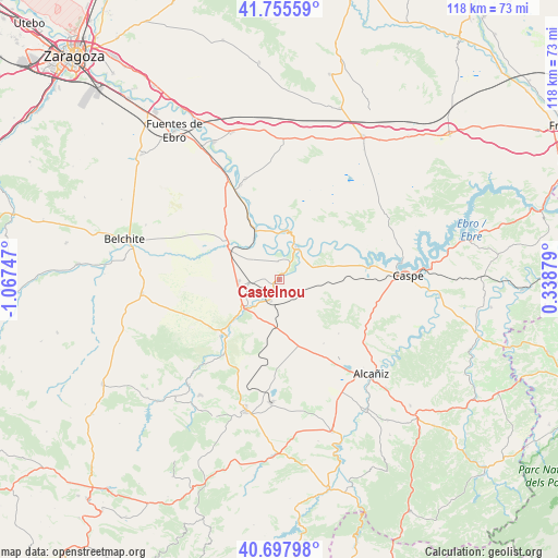
Castelnou GPS coordinates[2]
41° 13' 44.112" North, 0° 21' 51.624" West
| Map corner | latitude | longitude |
|---|---|---|
| Upper-left | 41.75559°, | -1.06747° |
| Center: | 41.22892°, | -0.36434° |
| Lower-right: | 40.69798°, | 0.33879° |
| Map W x H: | 117.6×117.6 km | = 73.1×73.1mi |
| max Lat: | 43.74134° ⇑46.1% North |
| Castelnou: | 41.22892° |
| min Lat: | ⇓53.9% South 27.64134° |
| min Long | Castelnou | max Long |
| -18.00367° | -0.36434° | 4.2899° |
| W 83.7%⇐ | ⇒16.3% E |
Elevation
Elevation of Castelnou is 194 m = 636 ft, and this is 404 m = 1325 ft below average elevation for this country.
| Max E: |
1682 m = 5518 ft | 81.6% |
| Avg. | 598 m = 1962 ft | |
| Castelnou | 194 m = 636 ft | |
Min E: |
0 m = 0 ft | 18.4% |
See also: Spain elevation on elevation.city.
Geographical zone
Castelnou is located in North temperate zone (between Tropic of Cancer and the Arctic Circle). Distance of this Northern Tropic circle is 1978.3 km =1229.3 mi to South.| Distance of | km | miles | from Castelnou |
|---|---|---|---|
| North Pole | 5422.8 | 3369.6 | to North |
| Arctic Circle | 2816.9 | 1750.3 | to North |
| Tropic Cancer | 1978.3 | 1229.3 | to South |
| Equator | 4584.2 | 2848.5 | to South |


Nearby cities:
15 places around Castelnou: (largest is in red/bold)
• Albalate del Arzobispo
17.1 km =10.6 mi,  225°
225°
• Alborge
11.7 km =7.3 mi,  3°
3°
• Alforque
11.3 km =7 mi,  351°
351°
• Almochuel
16.6 km =10.3 mi,  290°
290°
• Chiprana
20.2 km =12.6 mi,  79°
79°
• Cinco Olivas
12.3 km =7.6 mi,  357°
357°
• Escatrón
7.8 km =4.8 mi,  26°
26°
• Gelsa
21.5 km =13.4 mi,  337°
337°
• Híjar
9.5 km =5.9 mi, 230°
• Jatiel
1.8 km =1.1 mi,  236°
236°
• La Puebla de Híjar
6.4 km =4 mi,  263°
263°
• La Zaida
12.2 km =7.6 mi,  333°
333°
• Samper de Calanda
4.9 km =3 mi,  204°
204°
• Sástago
10.4 km =6.5 mi,  6°
6°
• Velilla de Ebro
17.2 km =10.7 mi, 339°
Sources, notices
• [Note1] Compared only with cities in Spain existing in our database
• [Src1] Map data: © OpenStreetMap contributors (CC-BY-SA)
• [Src2] Other city data from geonames.org with taken over terms of usage.
• [Src3] Geographical zone / Annual Mean Temperature by Robert A. Rohde @ Wikipedia
