Sant Pere de Ribes geodata
Sant Pere de Ribes (Catalonia) is a populated place; located in Spain in Europe/Madrid (GMT+2) time zone. With population of 28,353 people, there are 328 cities with bigger population in this country. Compared to other cities in Spain, 54.6% of cities are located further ↓South; 92.5% of cities are located further ←West and 91.2% of cities have higher elevation than Sant Pere de Ribes. Note1


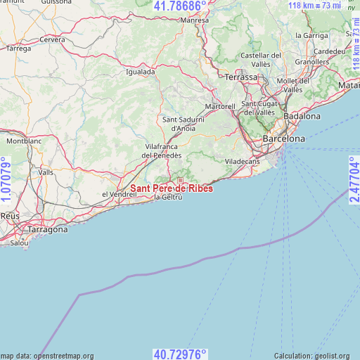
Sant Pere de Ribes GPS coordinates[2]
41° 15' 37.62" North, 1° 46' 26.076" East
| Map corner | latitude | longitude |
|---|---|---|
| Upper-left | 41.78686°, | 1.07079° |
| Center: | 41.26045°, | 1.77391° |
| Lower-right: | 40.72976°, | 2.47704° |
| Map W x H: | 117.5×117.5 km | = 73×73mi |
| max Lat: | 43.74134° ⇑45.4% North |
| Sant Pere de Ribes: | 41.26045° |
| min Lat: | ⇓54.6% South 27.64134° |
| min Long | Sant Pere de Ri | max Long |
| -18.00367° | 1.77391° | 4.2899° |
| W 92.5%⇐ | ⇒7.5% E |
Elevation
Elevation of Sant Pere de Ribes is 50 m = 164 ft, and this is 548 m = 1798 ft below average elevation for this country.
| Max E: |
1682 m = 5518 ft | 91.2% |
| Avg. | 598 m = 1962 ft | |
| Sant Pere de Ribes | 50 m = 164 ft | |
Min E: |
0 m = 0 ft | 8.8% |
See also: Spain elevation on elevation.city.
Geographical zone
Sant Pere de Ribes is located in North temperate zone (between Tropic of Cancer and the Arctic Circle). Distance of this Northern Tropic circle is 1981.8 km =1231.4 mi to South.| Distance of | km | miles | from Sant Pere de Ribes |
|---|---|---|---|
| North Pole | 5419.3 | 3367.4 | to North |
| Arctic Circle | 2813.4 | 1748.2 | to North |
| Tropic Cancer | 1981.8 | 1231.4 | to South |
| Equator | 4587.7 | 2850.7 | to South |


Nearby cities:
15 places around Sant Pere de Ribes: (largest is in red/bold)
• Avinyonet del Penedès
10 km =6.2 mi,  4°
4°
• Begues
15.6 km =9.7 mi,  58°
58°
• Castelldefels
16.5 km =10.3 mi,  83°
83°
• Castellet
11.7 km =7.3 mi,  271°
271°
• Cubelles
10.3 km =6.4 mi,  235°
235°
• Cunit
13.4 km =8.3 mi, 238°
• La Granada
13.9 km =8.6 mi,  340°
340°
• Olesa de Bonesvalls
12.2 km =7.6 mi,  31°
31°
• Olivella
7.2 km =4.5 mi, 29°
• Sant Pere Molanta
10.1 km =6.3 mi, 343°
• Sitges
4.3 km =2.7 mi,  131°
131°
• Subirats
16.3 km =10.1 mi,  17°
17°
• Vilafranca del Penedès
11.5 km =7.1 mi,  326°
326°
• Vilanova i la Geltrú
5.8 km =3.6 mi,  225°
225°
• Vilobí del Penedès
17.1 km =10.6 mi,  322°
322°
Sources, notices
• [Note1] Compared only with cities in Spain existing in our database
• [Src1] Map data: © OpenStreetMap contributors (CC-BY-SA)
• [Src2] Other city data from geonames.org with taken over terms of usage.
• [Src3] Geographical zone / Annual Mean Temperature by Robert A. Rohde @ Wikipedia
