Piedralaves geodata
Piedralaves (Castille and León) is a seat of a third-order administrative division; located in Spain in Europe/Madrid (GMT+2) time zone. With population of 2,135 people, there are 2084 cities with bigger population in this country. Compared to other cities in Spain, 65.5% of cities are located further ↑North; 68.7% of cities are located further →East and 55.9% of cities have lower elevation than Piedralaves. Note1
Administrative division(s):
- Level 1: Castille and León
- Level 2: Provincia de Ávila
- Level 3: Piedralaves


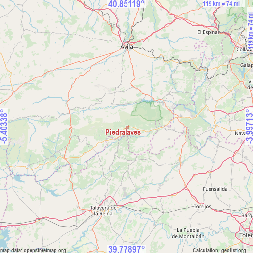
Piedralaves GPS coordinates[2]
40° 19' 1.956" North, 4° 42' 0.9" West
| Map corner | latitude | longitude |
|---|---|---|
| Upper-left | 40.85119°, | -5.40338° |
| Center: | 40.31721°, | -4.70025° |
| Lower-right: | 39.77897°, | -3.99713° |
| Map W x H: | 119.2×119.2 km | = 74.1×74.1mi |
| max Lat: | 43.74134° ⇑65.5% North |
| Piedralaves: | 40.31721° |
| min Lat: | ⇓34.5% South 27.64134° |
| min Long | Piedralaves | max Long |
| -18.00367° | -4.70025° | 4.2899° |
| W 31.3%⇐ | ⇒68.7% E |
Elevation
Elevation of Piedralaves is 715 m = 2346 ft, and this is 117 m = 384 ft above average elevation for this country.
| Max E: |
1682 m = 5518 ft | 44.1% |
| Piedralaves | 715 m 2346 ft | |
| Avg. | 598 m = 1962 ft | |
Min E: |
0 m = 0 ft | 55.9% |
See also: Spain elevation on elevation.city.
Geographical zone
Piedralaves is located in North temperate zone (between Tropic of Cancer and the Arctic Circle). Distance of this Northern Tropic circle is 1876.9 km =1166.3 mi to South.| Distance of | km | miles | from Piedralaves |
|---|---|---|---|
| North Pole | 5524.2 | 3432.6 | to North |
| Arctic Circle | 2918.3 | 1813.3 | to North |
| Tropic Cancer | 1876.9 | 1166.3 | to South |
| Equator | 4482.9 | 2785.5 | to South |


Nearby cities:
15 places around Piedralaves: (largest is in red/bold)
• Almendral de la Cañada
15.2 km =9.4 mi,  193°
193°
• Burgohondo
13 km =8.1 mi,  326°
326°
• Casavieja
6.8 km =4.2 mi,  236°
236°
• Casillas
10.9 km =6.8 mi,  84°
84°
• Fresnedilla
11.5 km =7.1 mi,  144°
144°
• Gavilanes
13.7 km =8.5 mi,  251°
251°
• Higuera de las Dueñas
11.9 km =7.4 mi, 136°
• La Adrada
5.8 km =3.6 mi,  109°
109°
• Mijares
11.8 km =7.3 mi,  258°
258°
• Navahondilla
17.3 km =10.7 mi,  87°
87°
• Navalmoral
16.9 km =10.5 mi,  340°
340°
• Navaluenga
10.5 km =6.5 mi,  355°
355°
• Navarrevisca
17.2 km =10.7 mi,  287°
287°
• Sartajada
14 km =8.7 mi,  214°
214°
• Sotillo de la Adrada
10.3 km =6.4 mi, 106°
Sources, notices
• [Note1] Compared only with cities in Spain existing in our database
• [Src1] Map data: © OpenStreetMap contributors (CC-BY-SA)
• [Src2] Other city data from geonames.org with taken over terms of usage.
• [Src3] Geographical zone / Annual Mean Temperature by Robert A. Rohde @ Wikipedia
