Lousame geodata
Lousame (Galicia) is a populated place; located in Spain in Europe/Madrid (GMT+2) time zone. With population of 3,862 people, there are 1505 cities with bigger population in this country. Compared to other cities in Spain, 92.2% of cities are located further ↓South; 98% of cities are located further →East and 84.5% of cities have higher elevation than Lousame. Note1


Lousame GPS coordinates[2]
42° 45' 53.172" North, 8° 50' 57.336" West
| Map corner | latitude | longitude |
|---|---|---|
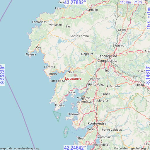
| Upper-left | 43.27882°, | -9.55238° |
| Center: | 42.76477°, | -8.84926° |
| Lower-right: | 42.24642°, | -8.14613° |
| Map W x H: | 114.8×114.8 km | = 71.3×71.3mi |
| max Lat: | 43.74134° ⇑7.8% North |
| Lousame: | 42.76477° |
| min Lat: | ⇓92.2% South 27.64134° |
| min Long | Lousame | max Long |
| -18.00367° | -8.84926° | 4.2899° |
| W 2%⇐ | ⇒98% E |
Elevation
Elevation of Lousame is 147 m = 482 ft, and this is 451 m = 1480 ft below average elevation for this country.
| Max E: |
1682 m = 5518 ft | 84.5% |
| Avg. | 598 m = 1962 ft | |
| Lousame | 147 m = 482 ft | |
Min E: |
0 m = 0 ft | 15.5% |
See also: Spain elevation on elevation.city.
Geographical zone
Lousame is located in North temperate zone (between Tropic of Cancer and the Arctic Circle). Distance of this Northern Tropic circle is 2149.1 km =1335.4 mi to South.| Distance of | km | miles | from Lousame |
|---|---|---|---|
| North Pole | 5252.1 | 3263.5 | to North |
| Arctic Circle | 2646.2 | 1644.3 | to North |
| Tropic Cancer | 2149.1 | 1335.4 | to South |
| Equator | 4755 | 2954.6 | to South |


Nearby cities:
15 places around Lousame: (largest is in red/bold)
• A Pobra do Caramiñal
19.4 km =12.1 mi,  202°
202°
• Boiro
13.4 km =8.3 mi,  192°
192°
• Carnota
20.6 km =12.8 mi,  288°
288°
• Catoira
14.9 km =9.3 mi,  136°
136°
• Muros
17.3 km =10.7 mi,  274°
274°
• Negreira
17.8 km =11.1 mi,  29°
29°
• Noia
3.9 km =2.4 mi,  306°
306°
• Outes
11.6 km =7.2 mi,  338°
338°
• Padrón
15.7 km =9.8 mi,  100°
100°
• Porto do Son
13.5 km =8.4 mi,  250°
250°
• Portosin
8.2 km =5.1 mi,  264°
264°
• Rianxo
13 km =8.1 mi,  168°
168°
• Rois
11.8 km =7.3 mi,  90°
90°
• Valga
18.7 km =11.6 mi,  113°
113°
• Vilagarcía de Arousa
20 km =12.4 mi,  159°
159°
Sources, notices
• [Note1] Compared only with cities in Spain existing in our database
• [Src1] Map data: © OpenStreetMap contributors (CC-BY-SA)
• [Src2] Other city data from geonames.org with taken over terms of usage.
• [Src3] Geographical zone / Annual Mean Temperature by Robert A. Rohde @ Wikipedia
