Cea geodata
Cea (Galicia) is a populated place; located in Spain in Europe/Madrid (GMT+2) time zone. With population of 2,960 people, there are 1736 cities with bigger population in this country. Compared to other cities in Spain, 86.6% of cities are located further ↓South; 96.2% of cities are located further →East and 60.7% of cities have higher elevation than Cea. Note1
Administrative division(s):
- Level 1: Galicia
- Level 2: Provincia de Ourense
- Level 3: San Cristovo de Cea


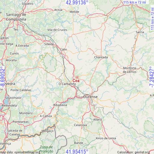
Cea GPS coordinates[2]
42° 28' 29.64" North, 7° 59' 14.604" West
| Map corner | latitude | longitude |
|---|---|---|
| Upper-left | 42.99136°, | -8.69052° |
| Center: | 42.4749°, | -7.98739° |
| Lower-right: | 41.95415°, | -7.28427° |
| Map W x H: | 115.3×115.3 km | = 71.6×71.6mi |
| max Lat: | 43.74134° ⇑13.4% North |
| Cea: | 42.4749° |
| min Lat: | ⇓86.6% South 27.64134° |
| min Long | Cea | max Long |
| -18.00367° | -7.98739° | 4.2899° |
| W 3.8%⇐ | ⇒96.2% E |
Elevation
Elevation of Cea is 518 m = 1699 ft, and this is 80 m = 262 ft below average elevation for this country.
| Max E: |
1682 m = 5518 ft | 60.7% |
| Avg. | 598 m = 1962 ft | |
| Cea | 518 m = 1699 ft | |
Min E: |
0 m = 0 ft | 39.3% |
See also: Spain elevation on elevation.city.
Geographical zone
Cea is located in North temperate zone (between Tropic of Cancer and the Arctic Circle). Distance of this Northern Tropic circle is 2116.8 km =1315.3 mi to South.| Distance of | km | miles | from Cea |
|---|---|---|---|
| North Pole | 5284.3 | 3283.5 | to North |
| Arctic Circle | 2678.4 | 1664.3 | to North |
| Tropic Cancer | 2116.8 | 1315.3 | to South |
| Equator | 4722.8 | 2934.6 | to South |


Nearby cities:
15 places around Cea: (largest is in red/bold)
• Amoeiro
7.2 km =4.5 mi,  154°
154°
• Boborás
13.7 km =8.5 mi,  250°
250°
• Carballedo
14 km =8.7 mi,  68°
68°
• Cenlle
17 km =10.6 mi,  209°
209°
• Coles
15.1 km =9.4 mi,  123°
123°
• Dozón
12.3 km =7.6 mi,  348°
348°
• Maside
7.8 km =4.8 mi,  203°
203°
• O Carballiño
8.9 km =5.5 mi,  237°
237°
• Ourense
18.4 km =11.4 mi, 146°
• Piñor
3.1 km =1.9 mi,  338°
338°
• Punxín
11.7 km =7.3 mi,  189°
189°
• San Amaro
13.3 km =8.3 mi, 212°
• Toén
17.7 km =11 mi,  171°
171°
• Vilamarín
8 km =5 mi,  98°
98°
• Vilarnaz
13.1 km =8.1 mi,  129°
129°
Sources, notices
• [Note1] Compared only with cities in Spain existing in our database
• [Src1] Map data: © OpenStreetMap contributors (CC-BY-SA)
• [Src2] Other city data from geonames.org with taken over terms of usage.
• [Src3] Geographical zone / Annual Mean Temperature by Robert A. Rohde @ Wikipedia
